Our Beautiful World

Kazakhstan
Its People and its beautiful Nature  
Part 2 - Its Nature


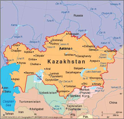
There are 5 geographical regions in Kazakstan: : Western, Northern, Central, Southern and Eastern.


http://www.moveoneinc.com/blog/relocations/enrelocation-kazakhstan/

But if Kazakhstan traveler had turned slightly off the ancient caravan route and headed north, he would soon get a very
different impression of the land where nearly every type of landscape that exists on our planet can be found. The poetic
heritage of Kazakhstan people contains captivating pictures of the land with its broad expanses, the enormous bulks of
snowcapped mountains and the azure mirrors of lakes.


Image courtesy of Maxim Koshkin


Only about 40 to 50 kilometers from the huge snow-white peaks rising in majestic succession, which look like the
pyramids of the Egyptian pharaohs magnified many times, begins the boundless steppe, a pale yellow plain stretching to
the very horizon. That is where you find the Social Lapwing bird at its breeding places at summer.

Now let's have a look into the 5 different parts of Kazakhstan.

Western region


There are 4 provinces (oblasts) in West, one of them Aktobe, which are shown on these pictures.
Courtesy: aboutkazakhstan.com

The greater part of Aktobe oblast is a raised plain broken by river valleys. In the center of the region are Mugodzhar Hills,
and in the south the desert sands of Aral Kara-Kum and Large and Small Barsuki.

The climate of Aktobe region is continental, and precipitation is low, particularly in the south. The river network of the
region is scanty. Main rivers of Aktobe oblast are Emba, Or and Ilek (both tributaries of Ural river), and Irgiz,
which flows into Shalkarteniz salt marsh.


Camels in Atyrau oblast
Photo: Dinara Satpayeva, Courtesy: aboutkazakhstan.com

Atyrau oblast is situated in southwestern Kazakhstan. Atyrau region is generally flat with Ural as main river.
The mainly sandy terrain is interspersed with salt marshes as shown in picture above.


Horses in an oasis in Mangystau
Horses - you find them everywhere in Kazakhstan.

Photo: Gómanenko Roman,
Courtesy: aboutkazakhstan.com

Mangystau oblast is the land of ancient civilization, an archeological open-air reserve. In 1,000 B.C. the land of Mangystau
was crossed by Great Silk way from Khorezm and Khiva to Europe and Middle East. Along this way on plateau Ustyurt
there were fortresses, settlements of craftsmen, cattle-breeders and hunters.


Even if this is a dry place, the tulips are still flowering here
Photo: Kobdabayev Amangali Courtesy: aboutkazakhstan.com

West Kazakhstan oblast, the last of four oblasts in the western region, lies mainly in Caspian Depression in dry steppe
and semidesert zones. The capital city of the region is Uralsk

Northern Region


Kostanay scenery
Photo: Sergey Likhota
,
Courtesy: aboutkazakhstan.com

Kostanay oblast (other spellings are Qostanay, Qostanai, Kostanai, Kustanai or Kus-tanai) is located in the northern
Kazakhstan, and is one of the two oblasts in this region. The capital city of the region is Kostanay. Kostanay oblast
contains a portion of Turgay Lowland, which lies between the foothills of Urals mountains and Kazakh Uplands and
connects West Siberian Plain in the north with Turgay Tableland in the south.


Scenery from North Kazakhstan oblast
Photographer unknown,
Courtesy: aboutkazakhstan.com

North Kazakhstan oblast includes steppe land, wooded in the northwest and the picturesque, hilly lake district in the south.
The highest point of North Kazakhstan oblast is Mount Sinyukha, 3,107 feet (947 m), near Borovoye (health resort).
North Kazakhstan oblast is located within forest steppe and steppe zones. About 8% of the territory is covered with forests,
mostly birch-tree ones.

Central region

   
Different Akmola oblasts sceneries.
Photographers: Utkin Mikhail,  Dmitry Sidorenko and  Dmitry Sidorenko,
Courtesy: aboutkazakhstan.com

Akmola oblast (also spelled Akmolinskaya) is a region of Kazakhstan that lies in the steppe zone in the northwest
Kazakh Upland and is drained by Ishim and Nura rivers.

In the southwest of Akmola oblast there are lakes Tengiz and Kurgaldzhin. The terrain of Akmola region is mainly rolling
plain, with black earth and chestnut soils in the north and center and saline brown soils in the extreme southwest and east.


Karaganda scenery
Photo: Olga Galkina, Courtesy: aboutkazakhstan.com

Karaganda, the second of the two oblasts in the Central region, or Karagandy (Kazakh people spelling) oblast (region)
of Kazakhstan lies mostly in Kazakhstan Uplands in dry steppe zone, rising gradually in elevation eastward to a maximum
in the Karkaraly Mountains of 5,115 feet (1,559 m).


The climate of Karaganda oblast is of sharp continental type: hot, dry summers, severe winters with little snow but with
winds and snowstorms. There are over 200 large and small rivers in the oblast. The main waterway in the oblast -
the river Nura crosses the oblast from east to west and flows into one of the largest lakes in Central Kazakhstan -
Tengiz. In the south the largest lake in Kazakhstan - Balkhash - is located. It is unique as water in its eastern part is salty,
in western part - it’s fresh.

Eastern region


East Kazakhstan river
Photo: Andrey Voskressensky,
Courtesy: aboutkazakhstan.com

East Kazakhstan oblast is the second in Kazakhstan Republic in milk and eggs production, the third-fourth in meat production.
Cattle-breeding is developed as well as coarse- and fine-wool sheep-breeding, wool goat-breeding, horse-
and pig-breeding, poultry-farming, antler reindeer-breeding and bee-keeping.


Photo: Konstantin Martalog,
Courtesy: aboutkazakhstan.com

The second oblast here in the East is Pavlodar region lands, which consist mainly of flat steppe,
which turns into semi desert in the southwest

Most part of Pavlodar oblast is occupied with steppe plains. One of the most beautiful places in Kazakhstan Republic -
Bayanaul - is located on the territory of the oblast. Mountainous regions, pine tree forests, lakes Zhasybai, Toraigyr,
Sabyndykol are among main tourist sites. In the north of the oblast there is the largest recreation area visited by tourists
from all over Kazakhstan and Russia.

Southern region


Photo: Andrey Voskressensky,
Courtesy: aboutkazakhstan.co

Almaty oblast (also spelled Almatinskaya, Alma-Ata) is situated in southeastern Kazakhstan. The capital of Almaty
oblast is Taldykorgan city. Almaty oblast origin of name: Kazakh for “grown with apple trees”, formerly Alma-Ata from alma:
apple, ata: father.


We just have to show two pictures from this oblast, to give a correct impression of this beautiful oblast.
Photo: Aleksey Ananchev,
Courtesy: aboutkazakhstan.co

The whole southern area of Almaty region is highly seismic. In the northern, plain part the climate is of sharp continental type,
cold winters (in January 9-10 degs C below zero), hot summers (in July about 24 degs C above zero).
Annual precipitation varies from 5 inches (125mm) in the plain to 32 inches (813 mm) in the mountains.


Who else can live here but these camels?
Photo: Ruslan Hisamutdinov
, Courtesy: aboutkazakhstan.co

Kzyl-Orda oblast (also spelled Kyzylorda) is situated in southern Kazakhstan. The region is located to the east of the
Aral Sea in the Low Syrdarya river, mainly within Turanskaya lowland (50-200 m high).
Large part of Kzyl-Orda oblast is covered by Aral Karakum and Kyzylkum deserts, making it one of the hottest and
most arid regions of Kazakhstan.

There are a lot of salt lakes (Zhaksy-Kykysh, Kamyslybas, Arys and others), they often turn dry by summertime; there is
curing mud in the lakes Kupek and Teresken. Considerable part of the territory is occupied with sand almost without any plants.


South Kazakhstan landscape with horses.
Photo: Mathias B.,
Courtesy: aboutkazakhstan.co

The center of South Kazakhstan oblast lies along the middle reaches of Syr Darya river. The north includes parts of
Muyun-Kum and Betpak-Dala deserts, and Kyzylkum Desert occupies the southwest. Mountains are confined to the center
and the southeast, where peaks rise to 14,100 feet (4,300 m). The climate of South Kazakhstan region is hot and dry.

and finally the last oblast of Kazakhstan:


Of course - more horses....
Photo: Ilker Ata,
Courtesy: aboutkazakhstan.co

The southern part of Zhambyl region includes the northern slopes of Kyrgyz and Karatau mountains and, in their foothills,
a narrow strip of fertile irrigated land.

In the center of Zhambyl oblast is the sandy Muyun-Kum Desert, which is separated by Chu River from the clay desert
of Betpak-Dala in the northern sector of the region. Zhambyl oblast has hot, dry summers and cold winters

We feel we have given a fair picture of the nature of Kazakhstan, and hope you agree that it is a beautiful country.
In such a diverse country, there ought to be a lot of wildlife, animals and birds etc.

Go to part III - Fauna

Go to part I - The People


bukkm.gif
ANIMALS

over 250

birdm.jpg
BIRDS

over 500

flower.jpg
FLOWERS

over 225
Google
 
Web www.vulkaner.no


This page has been made with Macromedia Dreamweaver