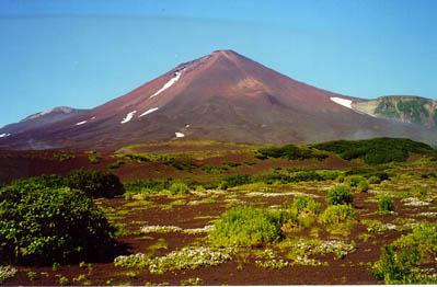
Lavaflows
from Chikurachki forms part of the Northwest coast. Chikurachki ha had
8
documented eruptions since its largest historic eruption in December
1853, when about 1
cubic-kilometer(!) tephra
was thrown out. The Tatariono-group which contains 6 volcano-
centers, is just south of Chikurachki. They have mainly eroded, and
only one historic eruption
is know, even fumaroles
have been active near a craterlake
up to 1959.
Friday, March 25th, 2005
KVERT has reported that according to satellite data from Russia,
a weak ash plume extending
about 70 km (or 43.5 mi) to the east was noted on March 23. The height
of the plume was
unknown. Clouds obscured the volcano at other times.
Eruptive activity of the volcano was first noted on March 12. Sudden
explosions of ash
as high as 6 km (19,700 ft.) ASL remain possible. Alert code ORANGE.
Friday, June 13th, 2003
As of the 12th of June, the Kamchatkan Volcanic Eruptions Response
Team (KVERT) has
reported that the eruption that began at Chikurachki on 18 April continued
during 30 May
to 6 June, with several explosions occurring. The highest rising ash
plume was emitted
on 28 May at 0900, rose 4 km above the crater, and drifted NE. An eruption
on the afternoon
of 29 May sent an ash plume to a height of 1.2 km above the crater and
deposited ash on the
town of Severo-Kurilsk. Chikurachki remained at Concern Color Code Orange.
According to the Leonid Kotenko (Severo-Kurilsk, Paramushir
Island) updated report on
May 30, from 19:30 till 23:10 local time on May 27, ash explosions up
to 500 m above the
crater of the volcano (2,300 m or 7,600 ft. ASL) were observed from
Shelekhov bay.
Ash plumes extended 70-80 km to the northeast. At 900 local time on
May 28, an ash plume
rose 4,000 m above the crater (5,800 m or 19,200 ft. ASL) and extended
>100 km to the
northeast. From 1030 local time on May 28, the height of ash plumes
decreased to 500 m
above the crater (2,300 m or 7,600 ft ASL). On May 29, low-level ash
plumes extended
15-20 km to the northeast. In the afternoon on May 29, an ash plume
rose ~1,200 m above
the crater (~3,000 m or 10,000 ft. ASL) and extended over Severo-Kurilsk.
Ash fell on the town. Explosions occurred continually.
Wednesday, May 15th, 2003
The eruption continues. Last week ashclouds have
been drifting in different direction.
Some times they have reached distances up to 400 km away. Owing to its
remote position
only few reports are received.
Saturday May 3rd, 2003
Ash coming from the Chikurachki volcano may contaminate water resources
in the north Kuril island of Paramushir. All the erupting particles
are soluble. Open basins are the only water source for the 3,000 residents
of the town of Severo-Kurilsk.
Moreover, the volcanic products may pollute rivers
and springs where Pacific Ocean salmon breed. At present, the volcano,
located 24 kilometers southwest of Severo- Kurilsk, is ejecting
ash and gas in two to four-hour periods.
The latest powerful eruption occurred on April 17-18.
Volcanic products covered the Vasilyev Peninsular in southern Paramushir
and the deserted village of Podgorny on the Pacific coast.
Rain carried them as far as Severo-Kurilsk. On April 26, a one millimeter
coating of ash fell
on the town.
www.interfax.ru
April 23rd, 2003

At
00:45, April 22, 2003
Chikurachki
volcano located on Paramushir Island in the North Kuriles beganerupting
on
April 18, 2003.According to data from the Aviation Meteorological Center
at Yelizovo
Airport on April 19, ash plumes rose 2,000 m above the crater of the
volcano (3,816 m or 12,500 ft. ASL).
According to visual data from Paramushir Island, on April 21, ash plumes
rose
500-1,000 m above the crater of the volcano (2,300-2,800 m or 7,500-9,200
ft.).

© Courtesy Geobotanica
Pacifica
Saxifraga
merkii chooses beautiful places to grow.
Here on the slopes of Chikurachki.

© Courtesy Geobotanica
Pacifica
Here
you can also find
Pennelianthus frutescens at the foot of
Chikurachki, in tephra from the 1853 eruption.
|