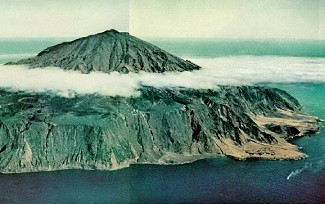
Tristan, and its neighbouring islands, lies about 400 km east of the
Mid-Atlantic Ridge.
The base of the volcano is at 3700 m below sea-level, and the summit
is at almost 2100 m
above sea-level. Marine erosion has formed the high, sheer cliffs (the
Main Cliffs) that
surround most of the island. Above the Main Cliffs is a more gently
sloping region between
600 and 1000 m (the Base).
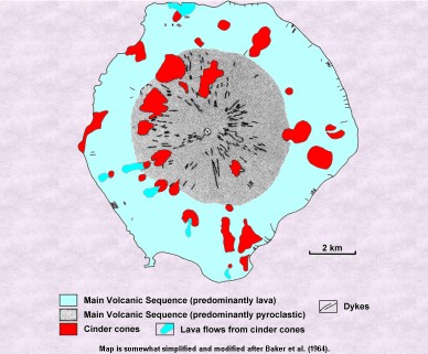
Rising from the Base is the steep central cone (the Peak) which has
a small summit crater.
The Peak predominantly is composed of pyroclastic deposits
erupted from the central vent.
The Base and Main Cliffs predominantly are composed of thin basaltic
lava flows, commonly
separated by thin pyroclastic layers. There are over 30 cinder cones
on the flanks of the main
volcano, many of which have produced small lava flows.

Map from National Geographic, May,
1962 issue.
The October 1961 eruption was preceded by earthquake swarms and rock
falls from the
Main Cliffs, then lava was erupted on the plain immediately east of
the settlement.
The growing lava mound breached and lava flows were erupted toward the
coast.
As the eruption waned, an elongate lava dome grew and sealed the vent.
All above except Nat.Geo.map, from
'Geology
of Tristan da Cunha', University of Oklahoma
Tristan Island is a dormant volcano with a lake in the top of the cone
which provides fresh
water. In October of 1961 the volcano erupted from a flanking vent next
to the settlement
and forced the evacuation of the entire population to Britain where
they lived unhappily for
a year. The eruption eventually destroyed the processing plant.
August 7th, 2004

Floating
rocks retreived by Tristan's fishermen
© SARTMA
Though all may seem quiet on the surface, the latest seismic
information from the Island is
quite different. Many kilometers beneath the 1961 Volcano the
rocks are still shaking.
Indeed, there has been other seismic activity along the Atlantic Ridge,
which has contributed
to this scenario.
The South Sandwich Islands have also experienced seismic activity within
the same time-
frame that Tristan did. No data has been received about the events
being related, however.
At the moment, fishermen from Tristan are reporting floating rocks all
around the Island.
(See the photo above) This is an indicator that the activity could
have been on the seabed.
Tristan da Cunha is located near to the Atlantic Ridge on the
African Plate and could
well receive pumice from eruptions on this spreading centre.
According to Tristanians, the 1961 volcano smokes and even vibrates
occasionally but no
one pays any attention to it.
Tristan Times
and SARTMA - TdC
August 3rd, 2004
A swarm of earthquakes struck Tristan da Cunha on the nights of 28 and
29 July 2004.
Further to reports published earlier on Tristan
Times Online, a swarm of earthquakes struck
Tristan da Cunha on the nights of 28 and 29 July 2004. According to the Preparatory
Commission for the CTBTO Vienna International Centre, the main swarm
lasted about
eight hours and was located 30km below the 1961 volcano.
After the main swarm, there were a few individual earthquakes. Seismic activity tapered
off since then, however, there has been no report received for 01 August
2004.
According
to Tristan Times the appropriate authorities in the UK have been informed,
although no one is thought to be in any danger from this most recent
seismic incident.
Latest: There has been a small land slide near the potato patches south-west
of the village.
|
Latest news always above. History is
below.
|

The island passed into obscurity until 1961, on August 6th tremors
and rockfalls were felt
behind the settlement which became more frequent as the weeks
passed.
Nobody could explain them and it was thought the heavy rain had
caused landslides.
At the beginning of October things got worse and a new fissure
was found to have opened
in the mountain side. The following day the earth tremors got
worse as the administrator
considered it wise to move the islanders away from the danger
zone and the whole population
was evacuted to Nightingale Island some 25 miles away.
 Wearied
by a long walk to safety and a cold night spent in sheds and on
open ground,
Wearied
by a long walk to safety and a cold night spent in sheds and on
open ground,
refugees set out for the fishing vessel Tristania, which will
ferry them to Nightingale Island,
one of Tristan's uninhabited neightbors.
From National Geographic,
May, 1962 issue
Examination of the site showed a mound had formed which was increasing
in size rapidly and
suggested imminent volcanic activity. A ship was scheduled to
call at Tristan to pick up half a
dozen passenger and was diverted to Nightingale to pick up the
290 residents to take them
to Capetown. As they passed Tristan they saw the volcano in full
eruption.
 Main
page to the article in National Geographic.
From National Geographic, May,
1962 issue
Main
page to the article in National Geographic.
From National Geographic, May,
1962 issue
The islanders were embarked for England in Capetown and were accomadated
at Calshot
near Southampton. At the turn of the year passing ships noted
the volcano was still erupting
and the traditional landing places had disappeared under lava.
The eruptions had died by
August 1962 and the Islanders voted overwhelmingly to return
and in November 1963 they did so.
In 1965, a new harbour was built for the re-establishment
of the Crawfish Industry and this
is now the Island's main industry, together with the sale of postage
stamps to collectors
and now the island has slipped back into obscurity remote from
civilisation.
From 'Tristan's History' by John
|
Search this site - Søk våre sider
|