![]()
|
Our
Beautiful World
|
Kanlaon National Park, Philippines
Part two: What is wrong with this World?
Part 1: Wildlife in Kanlaon NP - click here.
|
The Northern Negros Geothermal
Power Project
A Case Study by Simon Peter Gregorio http://www.ipc-ateneo.org/social_envtl_safeguards/discussion.php?aid=3 Mar-25-2004 The Northern Negros Geothermal Power Project is an 80-mw power plant to be constructed in the slopes of Mount Kanlaon Natural Park (MKNP) in the province of Negros Occidental. The project actually consists of two power plants, each generating 40 mw. One plant would be located in Barangay Minoyan, Municipality of Murcia and the other in Sitios Pataan and Hagdan, Brgy. Mailum, Bago City. In the original plan, the whole development area would cover around 4650 hectares, of which 1850 hectares would be located in the Mount Kanlaon National Park.
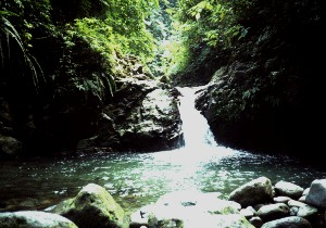
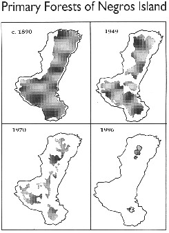
A protected area. Mt. Kanlaon is the highest peak in the central Philippines. The mountain sits almost at the center of Negros Island. It forms the north westernmost tip of the border dividing the Island into the two provinces of Negros Occidental and Negros Oriental. Jurisdiction over the volcano is disproportionately shared by the two Negros provinces and by four cities and two municipalities that have their common boundaries on the slopes of the volcano. These are the cities of Bago, La Carlota, San Carlos, and Canlaon and the municipalities of La Castellana and Murcia. Of the six, only Canlaon City is located in Negros Oriental. Mt. Kanlaon is one of the six most active volcanoes in the Philippines. Though it has not had a major eruption in the last 50 years or so, the volcano is prone to unpredictable pyroclastic explosions. Mt. Kanlaon is an important watershed area. It slopes are the origins of three Negros river systems. These are the Bago, Nahalin, and Ilog river systems. Seventy-five percent (75%) of the total land area of the MKNP or 18,418.2 has. are part of the Bago watershed. The Bago River originates from the northeastern part of the mountain. The Bago and Bilibago Irrigation Systems irrigates the province's so-called rice bowl. In 1990, the Bago Irrigation System was watering 15,000 hectares of agricultural land. Around half a million people in Negros Occidental are said to benefit from the waters of the Bago and Binalbagan river systems.  Along with the Northern Negros Forest Reserve on Mts. Mandalagan and Silay, Mt. Kanlaon hosts the remaining rainforests of the province. A Swedish Satellite Corporation survey showed that rainforests cover an estimated 11,475 has. or 46.73 percent of the park's area. The rainforests host a number of endangered plants like the Pitcher plant, staghorn fern, and orchid species like the Maripusa and Waling-waling and others. Plants endemic to the park are Cyrtanda cyclopum (Gesneriaceae) and two varieties of grasses that grow near the crater: Isachae vulcanica and Miscanthus depauperatus. There are also 50 species of animals distributed into 40 genera, 81 species of butterflies classified into 32 genera and belonging to four families, and 22 families of birds inside the park. Among the birds is the Yellow-backed sunbird which is found only in four islands in the CentralPhilippines (Sibuyan, Tablas, Panay, Negros, and Cebu).Other rare and endangered birds in Kanlaon are the Blue-crowned racquet-tailed parrot (Prioniturus discursus), Visayan tarictic hornbill (Penelopides panini), Flame-templed babbler (Stachyris speciosa), White-winged cuckoo-shrike (Coracina ostenta), and White-throated jungle flycatcher (Phinomyias albigularis). These birds inhabit the forest of the western portion of the mountain.
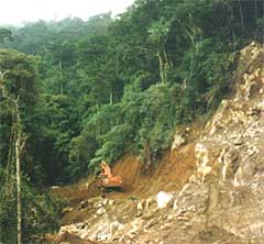
De-vegetation and the Subsequent Fragmentation of the Area: The plant would clear forests and vegetation where endangered species of flora and fauna might be living. Roads leading to the project would attract settlers and residents who would then encroach on the remaining rainforest. As a consequence, the animals would be disturbed from their habitats, thereby disrupting their breeding patterns. The incidence of soil erosion would increase, and the watershed would be compromised. There would be drought in the lowlands during the dry season and flash floods during the wet. Subsidence of the Surrounding Land: The geothermal plant would use up ground water faster than nature could replace them; creeks and streams would dry up and the surrounding land would sink. In Tiwi, Albay, where a geothermal plant is operating, several of the hot springs dried; in their place, new "hot spots" emerged in unlikely places like lawns, bedrooms, and kitchens. A number of families had to be evacuated.
Water Pollution: Opponents argue that geothermal exploration and operation would pollute watershed catchments, the ground water, river catchments, and tributaries with toxic geothermal effluents, chemical wastes discharges compromising the quality of drinking and irrigation water. Hot water discharged into the rivers and streams would raise the temperature of the water and damage fisheries and encourage the growth of weeds. They claim that in Tongonan, Leyte where PNOC operates a geothermal plant, rice yields declined from 29 cavans per hectare to four cavans per hectare because of the plant's wastewater discharges. In Tiwi, Albay, discharges from the plant allegedly contained concentrations of arsenic, barium, cadmium, chromium, copper, and lead that surpassed safety standards. Closer to home, the Palinpinon geothermal plant had supposedly polluted the Okoy River. Life forms in the river e.g. fish and shellfish had allegedly ceased to exist because of the high sulfuric content of the water. Some springs had also dried up as the geothermal plant sucked surface and ground water for its operations. Air Pollution and Acid Rain: Air emissions from geothermal plants contain hydrogen sulfide (H2S) and sulfur dioxide (SO2). SO2 in the atmosphere is the cause for acid rain. H2S at certain concentrations is known to harm the olfactory nerves (nerves in the eye) and even paralyze them. H2S is not easily removed from a place. Because it has a greater density than air, it is not easily carried by the wind and tends to remain at low-lying areas near the plant site. Go to part I Wildlife in Canlaon NP |
 ANIMALS over 250 |
 BIRDS over 500 |
 FLOWERS over 225 |


|
|

This page has been made with Macromedia Dreamweaver