![]()
|
Our
Beautiful World
|
Oil Exploration and Earthquakes
 |
|
|
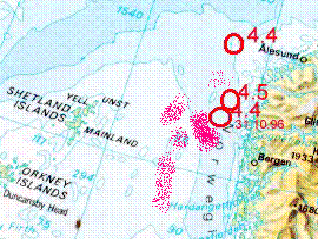
According to a news-report recently (feb-97) the bottom of the sea in this area is now some places 7 meter lower than 20 years ago.
In this area there have been several quakes during the past year,
magnitude in the area between 4.4 and 4.7. I know that is no reason
to panic. But - I can't help wondering what will happen if another
quake should reach the 5 or even 6 mark... |
|
 |
Anyone out there whom can give me a good answer, or explain to me what is going on, and why - if so - I do not have to worry??? E-mail me, please!: |
|
Even if quakes are being less frequent (?) I still wonder when
we are going to have a 6.0 or bigger out there in the North Sea
in between all the platforms.... |
|
Few years ago, the palatforms run by xxx in the Ekofish field area had to be raised. The oil production from the field had lowered the reservoir pressure which resulted in the gentle subsidence of the entire earth column (+-3000m) a total distance of about 5-10m. The details are somewhat hazy. (Why? bc) The same phenomenon occured in the Long Beach area of Los Angeles
back in the 1930's. There the surface dropped over 10m in places.
This was all due to oil production. |
|
Earthquake Details Magnitude 5.0 (Moderate) Date-Time Sunday, January 7, 2007 at 01:50:54 (UTC) Location 61.959°N, 1.152°E Depth 10 km (6.2 miles) set by location program Region NORWEGIAN SEA Distances 235 km (145 miles) NNE of Lerwick, Shetland Islands, UK 265 km (165 miles) W of Alesund, Norway 285 km (175 miles) NW of Bergen, Norway 1170 km (730 miles) N of LONDON, United Kingdom Location Uncertainty horizontal +/- 5.3 km (3.3 miles); depth fixed by location program Parameters Nst= 91, Nph= 91, Dmin=527 km, Rmss=1.02 sec, Gp= 58°, M-type=body magnitude (Mb), Version=7 Source USGS NEIC (WDCS-D) |
| I'm still wondering.... |
 ANIMALS over 250 |
 BIRDS over 500 |
 FLOWERS over 225 |


