Active volcanoes / Aktive vulkaner:
Eyjafjallajökull, Iceland
http://en.wikipedia.org/wiki/File:Eyjafjallajokull_volcano_plume_2010_04_18.JPG
|
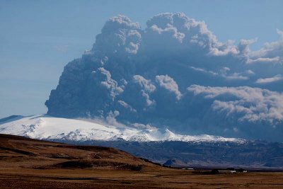
2010 During March 2010, the Icelandic Meteorological Office (IMO) and the Nordic Volcanological Center of the University of Iceland's Institute of Earth Sciences (IES) reported the first eruption of Eyjafjallajökull volcano in southern Iceland since 1823.  Base map courtesy of IMO. From 20 March to 12 April 2010 the eruption's first phase occurred from a fissure 9 km ENE of the summit, an area named Fimmvörðuháls, located between the Eyjafjallajökull and Mýrdalsjökull icecaps (map above). These vents on the lower E slopes were snow-covered but not under the year-round icecap found at higher elevations. Lava flows filled gullies, and quickly melted adjacent winter snow, creating small steam plumes.  Figure 2. Approximately N-looking interpretive cross-section cartoon drawn between Eyjafjallajökull and Katla. The eruption of 20 March was located at Fimmvörðuháls. Starting on 14 April, eruptions took place at the summit caldera. Notice the thin upper layer (blue on colored versions) representing glacial ice and the inferred common linkage at ~ 2 km depth below sea level of the conduits feeding the two active vent areas. From http://www.volcano.si.edu. Courtesy of Páll Einarsson (IES). After apparent cessation of the fissure activity on or about 12 April, a second phase of the eruption began on 14 April, generating ash plumes that blew E to Europe and resulted in a 20-80% decrease of airline flights for as much as a week. Late May the eruption continued, with occasional plumes that restricted air travel in parts of Europe. |
