Active volcanoes / Aktive vulkaner:
Bayonnaise, Japan
including Myojin-Sho
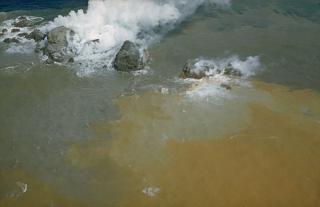
Bayonnaise Rocks, Pacific Ocean
(Photo from Smithsonian 'Global Volcanism Program')
|
The Bayonnaise Rocks submarine-volcano is one of the Japanese Izu Islands It raises only about 11 m asl (36 feet), and its relative position is 31.88°N 139.92°E  Bayonnaise Rocks represent part of the barely exposed rim of a largely submarine 8-9 km wide caldera. Formation of the caldera was followed by construction of a large (2.6 cu km) lava dome and/or lava flow complex on the caldera floor, originally located at a depth of 1000-1100 m. Most historical eruptions, recorded since the late-19th century, have occurred from Myojin-Sho, a large post-caldera lava dome constructed on the NE rim of the caldera. Deposits from submarine pyroclastic flows associated with growth of the dacitic lava dome mantle the conical dome and extend into the NE part of the caldera and down its outer slopes. It was 1869 when a volcanic eruption was first observed. Withinthe 130 years that followed, it has repeated more than ten volcanic activities of eruption and the appearance and disappearance of a new island. An explosive submarine eruption from Myojin-Sho in 1952 destroyed a Japanese research vessel, killing all 31 on board. Submarine eruptions have also been observed from other points on the caldera rim and outside of the caldera.  March 1st, 2004 According to ongoing survey by SWVRC, this volcano is forecast to erupt in 2004 with an accuracy of 95% probability. So now we just have to wait and see.....
The volcanic eruption from 1952 to 1953 was one of its biggest activities on record with the repetitious appearance and disappearance of an island. The island grew to more than several ten meters high at a certain point, but it disappeared with severe volcanic explosion in September 1953. The name Myojin-Sho derives from a fishing boat, "No.11 MYOJIN-MARU " of Yaizu City, Shizuoka Prefecture, the crew of which first witnessed the major volcanic eruption of 1952. On September 24, 1953, a survey vessel,"No. 5 KAIYO-MARU" of the Hydrographic Department of the Maritime SafetyAgency, met with disaster, costing thirty-one persons including those of nine scientists.This is the biggest disaster in the history of Japanese oceanographic research and an unforgettable tragedy for the Hydrographic Department. Determined to learn a lesson from this tragedy, the Hydrographic Department developed "MANBOU" (meaning Sunfish) an unmanned radio operating survey boat, and has used it for the research of dangerous sea areas such as submarine volcanoes, etc. The U.S. Navy SOFAR (Sound Fixing and Ranging) Stations off California detected the severe explosion, and Tsunami waves that accompanied theexplosion were observed in Hachijojima Island, about 130km north of the Myojin-Sho. Previously, Myojin-Sho was considered to be the central cone of a double volcano with the Bayonnaise Rocks (rocks of 9.9 meters in height above the sea level) as a portion of the somma (MITA, 1949). As a result of the survey, however, the authors found that both Myojin-Sho and the Bayonnaise Rocks are cones on the somma of a double volcano. The foot of this double volcano lies 1,400 to 1,500 meters in depth and the sizeis about 30 25 kilometers east-west, north-south. The somma is almost a circle in thediameter of 7 9 kilometers and the height is 1,000 – 1,400meters. The diameter of the caldera floor is 5.6 kilometers and about 1,100 meters in depth. The central cone is a high formerly known as Takane-Sho, height is 770 meters with theshallowest depth 328 meters. Myojin-Sho is a post caldera cone formed in the northeastern part of the somma of the double volcano. It is the single conical cone and the height is 550 meters with the shallowest depth 50 meters. A record that suggests a gushing of bubbles near thesummit was obtained and the micro earthquake were observed near the Myojin-Sho. Therefore, the authors consider that the Myojin-Sho continues to be active now although the level of the activity seems low. 02/70 Explosions and discolored water on 29 January; larger eruption on 3 February 03/70 Explosions in January and February detected by hydrophones 04/70 Eruption on 23 April sends water and smoke 200 m high 05/70 Detailed observations of activity from fishing boats and observation flights 07/70 Explosion bubbles and floating pumice on 18 June 07/79 Water discoloration observed on 13 July 1979 11/80 Discolored water 12/80 Discolored water seen on 23 December 10/87 Discolored water within 100 km 03/88 Discolored water Info on this page mainly from the Smithsonian 'Global Volcanism Program' and from THE SURVEY OF MYOJIN-SHO, by Kunio YASHIMA, Azuza NISHIZAWA and Yasyio OOTANI, Japan
Search this site - Søk våre sider |
