El Chichon is the most southern and eastern volcano in Mexico.
It is a small, but powerful andesitic tuff cone and lava dome
complex that occupies an isolated
part of the Chiapas region far from other Holocene volcanoes.
Prior to 1982, this relatively
unknown volcano was heavily forested and of no greater height
than adjacent non-volcanic
peaks. The largest dome, the former summit of the volcano, was
constructed within a
1.6 x 2 kilometer summit crater, created about 200,000 years
ago.
 This
is a view of the El Chichon caldera, formed during the
very explosive eruptions of late March and early April
of 1982. The caldera is about a kilometer wide and a few
hundred meters deep. Prior to the 1982 eruptions the summit
of the volcano consisted of a large lava dome within a
shallow caldera. There is a shallow acidic lake in the
caldera, fed entirely by ground water.
This
is a view of the El Chichon caldera, formed during the
very explosive eruptions of late March and early April
of 1982. The caldera is about a kilometer wide and a few
hundred meters deep. Prior to the 1982 eruptions the summit
of the volcano consisted of a large lava dome within a
shallow caldera. There is a shallow acidic lake in the
caldera, fed entirely by ground water. |
Two other large craters are located on the SW and SE flanks.
More than a half dozen large
explosive eruptions have occurred since the mid-Holocene. The
powerful 1982 explosive
eruptions of high-sulfur, anhydrite-bearing magma were accompanied
by devastating
pyroclastic flows and surges and destroyed the summit lava dome.
The eruptions created a new 1-kilometer-wide crater that now
contains an acidic crater lake.
El Chichon might have erupted from about 270 CE and every 500
to 600 year since, in about
700, 1350 and 1850, with explosive eruptions followed by pyroclastic
flows.
December
2007
In the aftermath of the 1982 eruption, El
Chichón's nearby flanks still contain abundant unstable
slopes,
and the new vegetation fails to keep up with the erosion rate.
Also, intracrater avalanches still occur, particularly
after heavy rainfall. The rumbling beneath the crater often
triggers small intracrater avalanches.
 The
crater lake at El Chichón when it contained the largest
water volume ever recorded here (26 March 2007).
Courtesy M. Jutzeler
The
crater lake at El Chichón when it contained the largest
water volume ever recorded here (26 March 2007).
Courtesy M. Jutzeler
The low-frequency tremor and rumbling beneath the crater floor
stemmed from fluid migrations
inside the boiling aquifer, sometimes causing small intra-aquifer
phreatic explosions.
Future El Chichón volcanism might take the form of intracrater
dome growth. Such growth could follow changes in
chemistry, temperature and dynamics of the crater lake, the
degassing regime, seismicity, geomagnetism, crater
morphology, or other unrest such as the onset of phreatic explosions.
Such processes can occur very rapidly,
as recently shown by the dome growth at Kelud,
Indonesia, in November 2007. However, the authors' investigation
found no evidence to support current dome growth.
The
1982 eruption
Then suddenly in 1982 it woke up again, way out of schedule.
Prior to 1982, it was thought to be extinct. Consequently, activity
of the volcano was not being
monitored and the 1982 eruption was a total surprise (although,
with hindsight, local inhabitants
had noticed increased earthquake activity for some months prior
to the first eruption).
Between March 28th and April 4th, El Chichon erupted violently
three times.
Pyroclasitc flows and surges destroyed villages within a 7 kilometer
radius of the volcano and
killed more than 2000 people. The eruptions destroyed the summit
dome of El Chichon,
leaving a one kilometer wide, 300 meter deep crater. It also
produced a total volume of 0.5
cubic kilometers of volcanic debris.

Ash and sulphur dioxide clouds above El Chichon after
the eruption. The greens show an intensity in aerosols,
the blues indicate the spread of the particles
From http://www.geocities.com/RainForest/Canopy/5236/el_chichon.htm
(Ikke
gyldig pr Sept. 2010) |
One thing to note about El Chichon, is that the eruption, although
not particularly large in terms
of the amount of volcanic ejections, did have significant atmospheric
effects and an impact on
global climate. The eruption was notable in that large volumes
of sulphur dioxide rich aerosols
were injected into the lower stratosphere and were dispersed
globally, causing brilliant sunrises
and sunsets over a large area of Earth and a decrease in the
amount of solar radiation reaching
the surface. The stratospheric cloud from the 1982 eruption
of El Chichon remained detectable
until late 1985! (See picture further down the page).
|
|
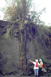
This photo shows how impressive some of the
1982
El Chichon pyroclastic flows were. Here two volcanologists
are examining a tree that was surrounded and killed by the
pyroclastic flow.
After the tree died, bushes started to grow on the new land
surface around the old dead trunk. Most recently, erosion
of the pyroclastic flows by a river has exposed much of
the
lower tree trunk again, giving a good indication of the
depth
of the pyroclastic flows, which was even deeper than
shown here since the base of the tree is still buried. |
What happened in 1982?
The eruption began 28 March at 23:32 and NOAA geostationary
weather satellite imagery
showed that the eruption column was about 100 km in diameter
40 minutes later.
Officials reported that as many as 100 persons may have been
killed by the eruption and
associated seismic activity. Tephra falls were very heavy near
the volcano, forcing tens of
thousands of residents to flee their homes, and causing major
damage to crops and livestock.
By 0530 the next morning, satellite images showed the main plume
extending from the Yucatán
Peninsula, S of Cuba, to Haiti
Heavy ashfall was reported from towns near the volcano. At Pichucalco,
~20 km NE of
the summit, 15 cm of ash was reported, and 5 cm of ash fell
at Villahermosa (population
100,000), 70 km NE of the volcano. Residents of Nicapa, a village
on the NE flank, took
refuge in a church that was toppled by a M 3.5 earthquake, killing
10 people and injuring
about 200. Initial estimates of the number of additional deaths
varied, ranging as high as 100,
and many more were probably killed on the SW flank during this
or subsequent eruptions
Most of the casualties on the N flank were reportedly caused
by fires started by incandescent airfall tephra.
Tens of thousands of people fled the area.
The heavy ashfall forced the closure of roads and the airports
at Villahermosa and Tuxtla
Gutiérrez (~ 70 km S of the volcano). Cocoa, coffee, and banana
crops were destroyed,
and the cattlemen's association requested that animals from
a wide area be transported for
butchering because ashfall had made grazing impossible.
|
|
Activity during 30 March-3 April 1982. A second but
much
smaller explosion was observed on the satellite imagery
at about
0900 on 30 March. A thin plume drifted E about 120 km
before dissipating. A somewhat larger explosion that was
first
visible at 1500 produced a cloud that rose into the mid-tropos-
phere and moved about 350 km N. Activity was declining
by 1900. Haze was widespread over central México, reducing
visibility to about 8 km inMéxico City ( ~ 650 km WNW of
the
volcano) and to only about 3 km in Tampico (~ 750 km NW
of the volcano). A small explosion shortly before 1330 on
31
March produceda plume that reached the upper troposphere
and blew to the E but dissipated quickly.
|
Activity during 4 April 1982.
A stronger explosion, possibly larger than the initial event
on
28 March, first appeared on the NOAA geostationary weather satellite
image returned at
0530 on 4 April and was reported by ground observers to have
started at 0522. An infrared
image 3.5 hours later showed a temperature of -76°C at the top
of the eruption cloud,
corresponding to an altitude of 16.8 km, identical to the altitude
measured from the
28 March plume.
At Ixtacomitán, 18 km ENE of the summit, there was a heavy fall
of tephra no larger than
4 cm in diameter and the army was sent to evacuate 3,000 residents.
No casualties were
reported. All villages within 15 km of the summit had previously
been evacuated and tens of
thousands of people had fled their homes. Government officials
reported ashfall over an
area of 24,000 km2 and crop damage of $55,000,000.
A pumice flow deposit from the 4 April eruption extended ~ 5
km NE from the summit,
terminating ~ 2 km from Nicapa. At its distal end, the deposit
was about 100 m wide and
3 m thick and contained pumice blocks 1 m in diameter. Temperatures
measured by a
thermocouple at 40 cm depth on 8 April averaged 360°C, and were
as high as 402°C.
The pumice flow deposit appeared to have been emplaced as two
separate events in rapid
succession. Shortly afterward, an ash flow flattened trees in
the valley surrounding the
pumice flow deposit and left a relatively thin layer of ash
that had a temperature of 94°C at
10 cm depth 3 days later.
Airfall tephra thickness in Nicapa, 7 km NE of the summit, totaled
25-40 cm after the 4 April
eruption. Bombs as large as 50-60 cm in diameter had made numerous
holes in the roofs of
houses and many other roofs had collapsed.
In Ostuacán, 12.5 km NW of the summit, tephra was 15-20 cm thick
after the 4 April
eruption, including pumice as large as 15 cm in diameter. Many
roofs had been destroyed.
Extreme heat made it impossible to approach the village of Francisco
León, 5 km SW of the
summit. Midway between Ostuacán and Francisco León, a river
was boiling and flattened
trees could be seen upslope. Geologists thought it was likely
that pyroclastic flows had moved
through the area. Of the roughly 1,000 residents of Francisco
León, about half had reportedly
left before the eruption because of the many felt earthquakes
in February and March, but the
remainder were missing in early April.
May activity and flood. Lakes
formed behind natural dams of new pyroclastic flow deposits
at several sites around the volcano. The largest lake, in the
valley of the Río Magdalena at the
SW foot of the volcano, grew about 1 m deeper each day until
26 April, then more slowly,
eventually reaching 5 km in length and several million m3
in volume. Late 26 May, the
pyroclastic dam holding back this water failed. Seismographs
recorded the draining of the lake
over a period of about 1 hour, sending a flood of hot water
downstream. At Ostuacán, more
than 10 km from the dam, the water temperature was measured
at 82°C. Most residents of
low-lying areas had been evacuated, but at a hydroelectric project
35 km downstream one
worker was killed and three were badly burned by 52°C water.
The flood also destroyed a
bridge several kilometers from the pyroclastic dam.
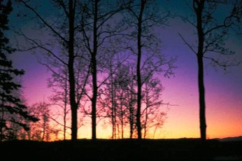 The
glow above is strongly purplish because of the presence
of dust in
The
glow above is strongly purplish because of the presence
of dust in
the stratosphere, at an altitude of approximately 20 km
(66,000 feet).
The colorful twilight that one could see in Alaska
from the eruption
of El Chichon volcano in Mexico |
Pyroclastic flows and casualties.
Major erosion of pyroclastic flow deposits around
El Chichónhas taken place since the eruption. Some small accumulations
of water remain
associated with these deposits, but there have been no recent
observations of large lakes
such as the one that produced a fatal flood 26 May. The largest
eruption killed many people
in and near the village of Francisco León (~ 5 km SW of the
summit), but initial reports that
all of its residents died were incorrect, according to an American
missionary who had lived
in the village for many years. Many villagers who had fled the
heavy tephra falls from the initial
explosions 28-29 March, however, returned a few days later.
About 140 residents of the
village itself and a similar number from the countryside nearby
were killed by the pyroclastic
flow that destroyed the village 4 April
Residents of the municipio of Francisco León, destroyed by a
pyroclastic flow 4 April,
estimate that about 400 people in the area were killed by the
eruption, and the Catholic
diocese of Tuxtla Gutiérrez has a list of more than 1,000 persons
believed to have died.
The eruption was also reported to have killed most of the birds
near the volcano. As a result,
insects multiplied and devoured crops planted at the beginning
of the rainy season, leaving
many farmers without food. Coffee, which normally provides a
cash crop, survived the
eruption but appears unlikely to produce any beans in 1982.
The Mexican government has
resettled people from heavily damaged villages onto land in
other parts of the state of Chiapas.
By the end of July, few of the 60,000 refugees from the eruption
remained in temporary camps.
Most photos on this page from NODAK EDU, North
Dakota, USA
|