Active volcanoes / Aktive vulkaner:
Sarychev Peak, Kurilles

 Sarychev on Matua Island, lower left corner on the map. Sarychev Peak, one of the most active volcanoes of the Kuril Islands, occupies the NW end of Matua Island in the central Kuriles. The andesitic central cone was constructed within a 3-3.5 km wide caldera, whose rim is exposed only on the SW side. A dramatic 250-m-wide, very steep-walled crater with a jagged rim caps the volcano. The substantially higher SE rim forms the 1496 m high point of the island. Fresh-looking lava flows descend all sides of Sarychev Peak and often form capes along the coast. Much of the lower-angle outer flanks of the volcano are overlain by pyroclastic-flow deposits. Eruptions have been recorded since the 1760's and include both quiet lava effusion and violent explosions. One of the largest historical eruptions of Sarychev Peak in 1946 produced pyroclastic flows that reached the sea. Sunday, December 5th, 2010 Based on satellite image observations, SVERT reported that steam-and-gas emissions rose from Sarychev Peak on 28 November. Sarychev Peak does not have a seismic network; satellite imagery is the primary tool for monitoring many of the Kurile Islands volcanoes. Source: Sakhalin Volcanic Eruption Response Team (SVERT) 17 June-23 June 2009 The eruption from Sarychev Peak that began on 11 June continued through the 19th. SVERT reported another explosive eruption at 1730 UTC on 15 June, followed by the satellite observation of a plume early on 16 June that extended 360 km NW. The Tokyo VAAC estimated that the 16 June plume rose to an altitude of 9.7 km (32,000 feet) a.s.l., while higher ash clouds from earlier explosions reached 13.7 km (45,000 feet) altitude. Ash emissions continued during 17-18 June, causing ashfall in Yuzhno-Sakhalinsk, and gas-and-steam plumes spread NE and SW. Thermal anomalies were detected in satellite data on 18 and 19 June, but cloudy conditions prevented clear observations. One MODIS image on 18 June showed an ash plume spreading SW above the weather clouds. Although the Aviation Color Code was lowered from Red to Orange on 19 June, satellite observations showed that a diffuse ash cloud had spread approximately 20 km S and 40 km W of the volcano. Source: Sakhalin Volcanic Eruption Response Team (SVERT) 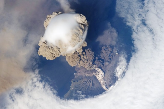 One
of the largest historical eruptions in the Kuriles took place June 11-16
from Sarychev Peak. |
