Active volcanoes / Aktive vulkaner:
Fukutoku-Okanoba, Japan
Submarine-volcano
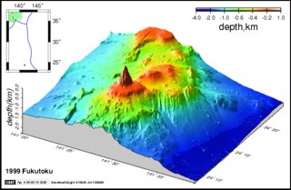
Fukutoku-Okanoba and vicinity shown in a 3-dimensional diagram, with color representing various elevation ranges;
vertical exaggeration is considerable but was not stated.
Copyrighted image courtesy of the Japan Coast Guard.
|
February 2010 Coast Guard vessels and aircraft are now collecting data in the area.
It is very dangerous to approach the area as it is
July 2005.
The Maritime Security and Safety Agency conducted an underwater topographical
survey on 20-22 July 2005, the result of which was the discovery of
two craters caused by the recent eruption. The results suggested that
the topography just S of those craters was newly raised. On 18 January, fishermen observed a large white plume rising to more than 3 km altitude and lava being ejected to about 300 m height form the vicinity of the submarine volcano Fukutoku-Okanoba. The eruption was first evident on infrared imagery from the Japanese GMS geostationary weather satellite on 18 January at 2100. Japan Maritime Self-Defense Force personnel stationed on Iwo-Jima, about 50 km from Fukutoku-Okanoba, observed a 4-km eruption cloud the next day at 1630. The Japan Maritime Safety Agency's survey ship Takuyo found a new island about 5 km NE of Minami Iwo Jima (south Iwo Jima) the morning of 21 January. The new island, about 700 m long and 300 m wide, extended about 15 m above sea level. Lava was being ejected to about 300 m height. As of 21 January, floating pumice had drifted 60 km to the SE.
By 18 January at 2000, eruptive activity was frequent, producing a dark plume, seen from a fishing boat, that reached 3,000-4,000 m height. An hour later the plume was evident on an image from Japan's GMS satellite. The next day at about 1630, airborne radar detected a plume rising to 4,000 m above sea level. On 20 January at 0440, radar on the JMSA's survey ship Takuyo showed an island-like image. A gray plume rose to 2,000 m altitude at 0550.
A new island was recognized by observers on the Takuyo at 0630. A 50-m vent at the NW edge of the new island ejected plumes and sea water. Continuous observations were made until about 1000. The island was ~700 m long, 500 m wide, and 15 m high (figure 2). A vent near its E edge remained below sea level, ejecting black incandescent rocks as much as 10 m in diameter. Grayish brown pumice had drifted as much as 18 km NE from the vent. Discolored sea water surrounded the island and extended 22 km NE from the vent. The sea water was greenish near the island, gradually becoming greenish yellow or pale blue farther from the vent. The island formed 20 January . . . has been eroded away by wave action since volcanic activity ceased. The island's disappearance was reported by the JMSDF after an hour-long helicopter flight that began 8 March at 0745. The surface of the new edifice was seen under white water, and there was no sign of a volcanic plume. On 28 January, airplane pilots observed light brown floating pumice within a roughly rectangular NW-SE-trending zone ~200 km long by 50 km wide, extending from ~100 to 300 km SE of the volcano. The pumice was in subparallel teardrop-shaped rafts roughly 4 km wide and 10 km long, elongate perpendicular to the apparent direction of drift. March 25, 1975 A U.S. Air Force reconnaissance flight operating out of Guam sighted an area of oceanic volcanic activity 32 km S of Iwo Jima. The sighting was described as possibly an island in the formative stages. |


