Active volcanoes / Aktive vulkaner:
Rumble III, Kermadec
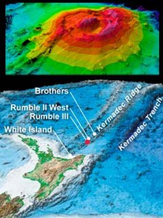
Image: GNS Science – Image may be subject to copyright.
|
The 2300m Rumble III forms part of the Kermadec Ridge, a jagged chain of 30 large underwater volcanoes that ascend from the ocean floor between New Zealand and Tonga. This area has the highest activity of submarine volcanoes building up new islands, just to disappear again soon after. "The Rumbles" consist of five volanoes, Rumble I to V. The Rumble III seamount, the largest of the Rumbles seamount group along the South Kermadec Ridge, rises 2300 m from the sea floor to within about 200 m of the sea surface. Collapse of the edifice produced a horseshoe-shaped caldera breached to the west and a large debris-avalanche deposit. Fresh-looking andesitic rocks have been dredged from the summit of Rumble III and basaltic lava from its flanks. Rumble III sits on the southern ridge of the Kermadec Arc of about 100 submarine volcanoes Rumble III has been the source of several submarine eruptions detected by hydrophone signals. Early surveys placed its depth at 117 m, and later depths of about 200 m, 140 m, and 220 m were determined. Recent eruptions were in 1958, -63, -70, -73 and -86. August
17, 2010
National Institute of Water and Atmospheric Research scientists found that a volcanic cone on Rumble III, 200km northeast of Auckland, had crumbled. The volcano's highest point had dropped 90m further below the Pacific Ocean, and in some places the volcano had slipped as much as 120m. The collapse was caused by an eruption some time in the last two years. The volcano was last mapped by Niwa in 2002 using multibeam technology, a sonar-like system that gives scientists a digital image of its terrain. In June that year the collapse on the western flank of the volcano was confirmed by Niwa on an oceanographic voyage on the RV Tangaroa. The discovery provided a rare insight into the movements of the seabed
over a short timespan. The information to gauge the potential impact of a larger collapse
on New Zealand's shores. Rumble III's peak
|
