Active volcanoes / Aktive vulkaner:
Jebel at Tair and Jebel Zubair, Yemen
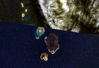
The 5-km-long Jebel Zubair Island (lower center) is the largest of a group of 10 small islands and submerged shoals.
Late-stage explosive and effusive activity has taken place on the islands of Zubair, Centre Peak (SW of Zubair),
and Saba (NW of Zubair). Historical explosive activity was reported in the 19th century from Saddle Island,
the largest of three small islands at the upper left.
NASA Landsat7 image (worldwind.arc.nasa.gov)
 Volcanic Island of Jebel at Tair, Yemen, in the Red Sea (Image credit: Global Volcanic Program, Smithsonian National Museum of Natural History) Read more about the Zubair Island Group on bottom of page. Jebel at Tair The basaltic Jebel at Tair volcano rises from a 1200 m depth in the south-central Red Sea, forming an oval-shaped island about 3 km long. Jebel at Tair (one of many variations of the name, including Djebel Teyr, Jabal al Tayr, and Jibbel Tir ) is the northernmost known Holocene volcano in the Red Sea and lies SW of the Farisan Islands. Youthful basaltic pahoehoe lava flows from the steep-sided central vent, Jebel Duchan, cover most of the island. They drape a circular cliff cut by wave erosion of an older edifice and extend beyond it to form a flat coastal plain . Pyroclastic cones are located along the NW and southern coasts, and fumarolic activity occurs from two uneroded scoria cones at the summit. Radial fissures extend from the summit, some of which were the sources of lava flows. The island is of Holocene age, and explosive eruptions were reported in the 18th and 19th centuries. More about Jebel at Tair - click here.  The
island of Saba, just north of Zubair. Looking west. (WNW) The
island of Saba, just north of Zubair. Looking west. (WNW)Probably Connected Island to the left, and Low Island and Table Peak up to the right.. Photo © Eric Lafforgue, http://www.ericlafforgue.com/  Compare this picture of Saba Island with the coastline above.... Jebel Zubair The 5-km-long Jebel Zubair Island is the largest of a group of 10 small islands and submerged shoals that rise from a shallow platform in the Red Sea rift. The platform and eruptive vents forming the islands and shoals are oriented NNW-SSE, parallel to the rift. An early explosive phase was followed by a brief period of marine erosion, and then by renewed explosive activity accompanied by the extrusion of basaltic pahoehoe lava flows. This latest phase of activity occurred on the morphologically youngest islands of Zubair, Centre Peak, Saba, and Haycock. Historical explosive activity was reported from Saddle Island in the 19th century. Spatter cones and pyroclastic cones were erupted along fissures that form the low spine of Zubair Island. http://www.volcano.si.edu Thursday, January 19th, 2012.  It now looks like the eruption is over, as no activity seen on this picture, taken January 15th. The new island is about 500 m N of Rugged Island, and is more than 500 m long. Now we have to see what comes first, birds or insects - like on Surtsey. Monday, January 7th, 2012  This new satellite image, acquired January 7, 2012, suggests that the eruption has risen nearly completely above water. A plume of steam, other volcanic gases, and ash spews from a distinct cone. The land surrounding the vent has grown, and is now about 530 by 710 meters (1,700 by 2,300 feet) across. Once above water, past eruptions in the Zubair Islands were primarily effusive, with relatively runny lava forming thin lava flows. In contrast to the fragmented rock that forms when lava interacts directly with water, lava that solidifies on land is tough, so this new island is likely to stick around. (text NASA earth observatory).  Videos uploaded to Youtube.com January 2nd. 2012. Place and volcano yet unknown, but what else could it be? Thursday, December 29th, 2011
An eruption occurred in the Red Sea in December 2011. According to news reports, fishermen witnessed lava fountains reaching up to 30 meters (90 feet) tall on December 19. The Moderate Resolution Imaging Spectroradiometer (MODIS) on NASA’s Terra and Aqua satellites observed plumes on December 20 and December 22. Meanwhile, the Ozone Monitoring Instrument (OMI) on NASA’s Aura satellite detected elevated levels of sulfur dioxide, further indicating an eruption.  acquired December 23, 2011 http://earthobservatory.nasa.gov/  acquired October 24, 2007 http://earthobservatory.nasa.gov/ The activity in the Red Sea included more than an eruption. By December
23, 2011, what looked like a new island appeared in the region. The
Advanced Land Imager (ALI) on NASA’s Earth Observing-1 (EO-1)
satellite captured
December 30th we found the following in a notice about Zubair: "The island is currently around 500m wide and is still growing." http://zeenews.india.com Thursday
December 22nd, 2011 Tuesday,
December 20th, 2011
 Small plume potentially from a new eruption at Jebel Zubair. MODIS image taken on December 20, 2011. Image courtesy of NASA and clipped Update: It seems like there is a lot of confusion about exactly where the eruption is taking place. A number of sources put the eruption at Jebel Zubair, another island volcano that is part of an archipelago that last erupted in 1824. Jebel Zubair is just to the south of Jebel at Tair, so looking at the OMI map and the new MODIS image found by Eruptions reader Kirby that looks to have a small plume (see above), it is more likely Jebel Zubair. However, there is still not a lot of information out there on this eruption. http://www.wired.com/wiredscience/tag/jebel-zubair/ A possible eruption occurred at Az Zubair archipelago on 19th December 2011. Fishermen from Salif port city in the west of Yemen reported seeing an eruption with red lava rising to a height of 30 m. This was the first eruption the fisherman can recall from the area. Satellite images showed raised sulphur dioxide emissions close to the volcano on the following day The site of the eruption could be the volcanic island of Jebel at Tair Jebel at Tair is a known active volcano, having erupted as recently as 2007-08, when seven Yemeni soldiers were killed, www.accuweather.com/en/weather-news/yemen-volcano-eruption-reporte/59286?utm_source=dlvr.it&utm_medium=twitter  30 November 2007. Night-time photograph of lava fountains and incandescence from the summit crater at Jebel at Tair. Material was estimated to be rising 20-50 m as viewed from 6-7 km offshore during the night. Courtesy of Lars Melin. From Global Volcanic Program, Smithsonian National Museum of Natural History  Fire fountains rising from a fissure eruption at Jebel at Tair, 30 September 2007. Infrared photo taken from the deck of the Canadian frigate HMCS Toronto offshore of the island. Photo by MCpl Kevin Paul, Canadian Forces Combat Camera. From Global Volcanic Program, Smithsonian National Museum of Natural History November 2008 On 30 September 2007 an eruption began on the island of Jebel at Tair (BGVN 32:10) that generated a large SO2 plume, sent lava flows into the sea, and resulted in the deaths of Yemeni soldiers. Observations of continuing activity were made in late November-early December 2007, and also in mid-January 2008, but no other eyewitness reports have been received since that time. However, satellite data indicated continuing thermal anomalies, indicative of hot lava flows, into mid-May 2008. Learn more about Yemen - click here |

