|
Grimsvotn volcano (N 64.41°, W 17.33°), situated near the center
of the Vatnajokull ice cap
in central Iceland, is one of Iceland's most active volcanoes. It has
a complex of calderas,
and a subglacial caldera lake sustained by geothermal heat. Small eruptions
have occurred
at the volcano in 1983 and 1998 (around 0.1 km3). In 1996, the Gjalp
subglacial eruption
occurred north of the volcano. The most recent eruption triggered by
a pressure release as
the current eruption occurred in 1934.
Vatnajökull covers an area of 8.100 km². The volume of the icecap is
almost 3.000 km³.
The icecover is about 400 m thick (average), and at the most about 950
meters!
Since 70 % of the surface is above 1.100 m asl, it is still alive. If
it should disappear,
it would not be able to build up again under the present climatic situation.
In the western part of Vatnajökull lie the volcanoes Barðarbunga and
Grimsvötn, in north
Kverkfjöll and in the eastern part Breiðubunga.
Sorry, no updates Saturday or Sunday this week
Friday,
November 5th, 2010
During the last 24 hours, tremor levels at seismic station 'grf' have
declined considerably.
Discharge measurements from the Gígja bridge show that the jökulhlaup
peaked yesterday between 13:00
and 14:00 GMT; at this time, the maximum discharge was ~2,600 m3/s.
Electrical conductively levels in Gígja river remain high, signifying
continued drainage of meltwater from Grímsvötn.
Presently, there are no detectable signs of the beginning of a volcanic
eruption at Grimsvötn.
norvol.hi.is
And that
is it, so far. Meanwhile Merapi in
Indonesia has had its most violent eruption so far.
Thursday,
November 4th, 2010
12.00 GMT (UTC) no further news, except that water leveld in Gigja river
has reached 2.000 cubic meters/second
and probably that will be the peak. Seismic activity small.
Wednesday,
November 3rd, 2010
The water level in Gígja River has been rising. On Wednesday
morning early the level was at 4.8 meters
and the flow was 1,650 cubic meters/second Tuesday evening.
This compares with 3.8 meters and 630 cubic meters on Tuesday morning.
Tuesday evening the river had expanded to its maximum
level at the bridge over the river.
Many lagoons and ponds had formed by the end of the glacier in a 24
hours space.
Some of the water from Grímsvötn volcano had flowed into
the Súla River. However, the flow in Súla is very limited.
No earthquake activity has been recorded in Grímsvötn
in the last 24 hours.
Tuesday,
November 2nd, 2010
Tuesday evening
Discharge is still increasing from Grímsvötn but the rate
of increase has slowed down.
Discharge was measured at 1200 m3/s this morning.
Two earthquakes occurred beneath Grimsvötn yesterday evening: 18:50
GMT and 20:59 GMT.
Today, two earthquakes have been monitored: 06:06 GMT and 06:42 GMT.
The magnitudes of these earthquakes are between 1,2 to 1,5.
One icequake was observed this morning at the western edge of Skeiðarárjökull
indicating that a floodwater
is propagating beneath the glacier.
GPS: Horizontal movements indicate that the pressure level may be comparable
to the situation before the 2004 eruption.
http://www2.norvol.hi.is/
Tuesday
morning
One of the first signs that a colcano starts becoming restless, is that
the level of water in rivers coming down from the volcanoslopes are
increasing. The volcanoes on Iceland are mostly covered by ice and snow,
which make visual observations impossible. Of course, level of seismicity
is also monitored, but smaller quakes occur all the time.
Now the river Gigja has tripled the water levels since Monday morning.
The water coming down here from the
Vatnajoekull glacier comes from an icy lake in the crater of the Grimsvotn
volcano.
The thermal temperatures in the crater have increased, and the ice sorrounding
the crater is melting.
The water is filling the crater to a point where it has spilled over,
and two thing happens.
Waterlevel in the river(s) are increasing, and water or vapour may sink
into the volcano. This can set off an eruption.
At the same time, as the ice disappears, the pressure on the volcano
is released, and with less pressure - again there
is a chance that we will have an eruption. Now it all depends how much
magma is stored on top of the volcano.
During the past 2 days, there have been several earthquakes in the area,
of which 3 of them where on 2.7 to 4,0
on Richter scale. What
to happen next, we just have to see. Whether it will be like the eruption
earlier this year from Eyjafjoell, which nearly stopped all air traffic
in Europe for a while, or just an ordinary small eruption that will
make no harm, is yet to see.
Flood waters are steadily and rapidly rising. Melting glacial waters
coming through the Gígjukvísl area have increased
from 140 cubic meters a second midday Sunday to 455 cubic meters per
second by noon Monday, and 630 cubic
meters per second at 17:30 Monday
A large chunk of ice carried by the melting waters smashed
into a high tension cable tower, knocking out all electricity
in the town of Kirkjubæjarklaustur. Workers are currently trying
to repair the damage and restore power to the town.
The flood waters continue to rise.
To learn more of what can happen, please read further down.
Monday, November 8th, 2004

Photo:
© Magnús Tumi Guðmundsson, www.jardvis.hi.is.
The eruption at Grimsvötn volcano ceased
between Friday night and Saturday morning,
November 6, 2004.
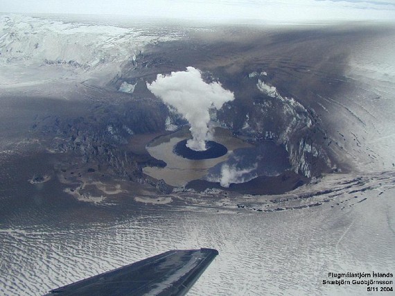
Grimsvötn
crater on November 5th.
Courtesy © Snæbjörn Guðbjörnsson, ICAA.
www.jardvis.hi.is.
November 5th, 2004

An explosion in the morning of November 4th.
Photo: © Fredrik Holm,
www.norvol.hi.is
Eruption of the Grimsvotn volcano, Iceland:
Summary of activity November 1-4, 2004
| |
The eruption that started at the subglacial
Grimsvotn volcano in the Vatnajokull ice cap,
Iceland, on November 1, around 22 GMT (Sigmundsson et al., 2004)
is now declining.
Volcanic tremor decayed rapidly between November 2 and 4 and the
eruption plume is
greatly reduced, consisting now mostly of steam. Intermittent
phreatomagmatic explosions
were observed around noon on November 4, sending jets of ash and
fragmented ice about
1 km above the crater. The eruption plume rose to a height of
2-4 km. The ash fall is limited
well within the Vatnajokull ice cap.
The eruption takes place inside the Grimsvotn caldera near its
SW boundary. The eruption
was initially under 150-200 m thick ice and melted its way through
the ice cap in about 1 hour.
An eruption plume was detected by weather radar around midnight,
and reached an altitude
of 13 km during the night of November 2. The initial inspection
of the eruption from an
aeroplane around 8 GMT on November 2 confirmed that a phreatomagmatic
eruption was
in progress from a short (less than 1-km-long) eruptive fissure
at 64.40N, 17.23W. At that
time a continuous plume rose to an elevation of about 9 km. Observations
throughout the day
revealed periods of high explosive activity, with maximum plume
heights of 12-14 km.
The strength of the eruption correlated with the seismically recorded
volcanic tremor. Some
explosive activity had occurred in a second ice cauldron near
the SE edge of Grimsvotn,
8-km to the east of the main crater. This cauldron issued steam
when first detected in the
afternoon of November 2.
 A
second cauldron near Grimsvötn.
Photo:
© Fredrik Holm, www.norvol.hi.is
A
second cauldron near Grimsvötn.
Photo:
© Fredrik Holm, www.norvol.hi.is
The main tephra sector formed November 1-3 trends
to north-northeast as a result of strong
southerly winds. The sector is about 30 km wide near the north
edge of Vatnajokull at a
distance of 50 km from the eruptive site. Tephra fell in inhabited
areas in north and northeast
Iceland, but only in small quantities. The eruption plume was
seen on satellite images and ash
drifted over large parts of the North Atlantic and reached Scandinavia.
Air traffic was
disrupted; an area of 311 thousand square kilometres was closed
for flights from the
beginning of the eruption until the morning of November 4. Farmers
sheltered grazing animals
in North Iceland to prevent them from consuming soluble fluorine
adhering to ash grains.
On November 4, winds changed to north-westerly direction and in
the afternoon tephra had
been dispersed over the ice cap east of Grimsvotn.

|
In
the morning of November 2nd
Photo:
© Tórdís Högnadóttir, www.jardvis.hi.is.
|
After the onset of the eruption insignificant
earthquake activity occurred at the eruptive site,
but continuous low-frequency tremor has been recorded during the
eruption. The tremor
was steady for the initial 15-hours of the eruption. After that
it was pulsating and declining.
The jokulhlaup, the glacial outburst flood that
preceded the eruption by few days and
triggered the eruption (Sigmundsson et al., 2004), reached a maximum
in the afternoon of
November 2. At that time the peak discharge in the rivers on Skeidararsandur
was 3000-
4000 m3/s (based on information from the Icelandic Hydrological
Service). Discharge
declined fast after the peak. No damage has occurred to roads
or bridges. The total volume
of the jokulhlaup is about 0.5 km3.
The eruption follows a pattern similar to previous
eruptions in 1983 and 1998, with probably
less than 0.1 km3 of magma erupted. These eruptions, together
with the 1996 Gjalp eruption
north of Grimsvotn reveal much higher activity at Grimsvotn than
during the middle part of last
century, and may indicate that Grimsvotn is entering into a new
period of high volcanic activity
that may last for decades. Such a high activity period has been
predicted on the basis of the
observed cyclic volcanic activity in the area in the preceding
millennium (Larsen et al., 1998).
From NORVOL, Iceland, authors: Freysteinn
Sigmundsson, Pall Einarsson, Magnus Tumi Gudmundsson, Thordis
Hognadottir, Anette K. Mortensen, Institute of Earth Sciences,
University of Iceland, Reykjavik, Iceland.
Steinunn Jakobsdottir, Matthew Roberts, Kristin Vogfjord, Ragnar
Stefansson,
Icelandic Meteorological Office, Reykjavik, Iceland.
|
2.november 2004

From
the morning of November 2nd, 2004
Photo: ©
Freysteinn Sigmundsson
There is a planned overview flight at 7:30 in the morning. Hopefully
one will be able to confirm
where the eruption site is, and the style of the eruption.

Since about 22:00 yesterday, volcanic tremors have occured continiously
at Grímsvötn.
An eruption is ongoing, and the main-road south of Vatnajökull
between Núpstaður and
Skaftafell were closed around midnight.
1. november 2004

A
plume of steam and ash from an eruption of Grimsvötn volcano in
Iceland is seen
blowing northeast,with a well defines shadow beneath the plume. The
eruption began
about 10:00 PM Iceland time onNov. 1, 2004. Ash and a sulfur dioxide
layer were observed
over Norway on the morning of November 3rd.
Photo: http://www.osei.noaa.gov/
An eruption has probably started at Grimsvötn.
There have been abnormal seismic activity in about 20 minutes. Tremors
began earlier in
the morning this day, following a jökellaup which has been going
on since Thursday.

In
the morning of November 4th
Photo:
© Fredrik Holm, www.norvol.hi.is
| |
Release of overburden pressure triggers an eruption of Grimsvotn
volcano, Iceland.
The subglacial Grimsvotn volcano, Iceland, started erupting on
November 1, 2004 around
22 GMT. An intense swarm of volcanic earthquakes that started
about 3 hours earlier
changed at that time to continuous low frequency tremor, indicating
onset of an eruption.
Weather conditions prohibited direct observations of the beginning
of the eruption at this
remote volcano situated near the center of Europe's largest ice
cap, Vatnajokull.

|
In
the morning of November 2nd
Photo:
© Magnús Tumi Guðmundsson, www.jardvis.hi.is.
|
The eruption was preceded by both long-term and short-term precursors,
and finally
triggered by release of overburden pressure associated with a glacial
outburst flood
(jokulhlaup), originating from the Grimsvotn subglacial caldera
lake, that preceded the
eruption. Accumulation of magma in a shallow magma chamber under
the Grimsvotn caldera
has been ongoing since its last eruption in 1998 (Sturkell et al.,
2003; Sigmundsson et al.,
2004). GPS measurements show uplift of 5-10 cm/year in the caldera
center, and horizontal
displacements away from the caldera. Earthquake activity increased
in middle of 2003, at
about the same time uplift exceeded its 1998 maximum. Pressure in
the Grimsvotn magma
chamber is likely to have exceeded its pre-eruption level from 1998
at this time.Additional
uplift and expansion of the volcano since then suggested approaching
failure of the volcano.

Earthquake activity increased further in late October, 2004. Geothermal
heat sustains a lake
in the caldera that intermittently causes glacial outburst floods.
On October 26 high frequency
seismic tremor indicated increased water flow from the caldera
lake and suggested that a
glacial outburst flood was about to begin. On October 29 discharge
increased in river
Skeidara. The outburst flood was caused by high water level in
the Grimsvotn caldera lake
from ice melting by geothermal activity. The release in overburden
pressure associated with
the outburst flood triggered the eruption. The drop in water level
in the Grimsvotn caldera at
the onset of the eruption is uncertain, but is probably on the
order of 10-20 meters,
corresponding to a pressure change of 0.1-0.2 MPa on the volcano
surface. This modest
pressure change triggered the eruption because internal pressure
in the Grimsvotn shallow
magma chamber was high after continuous inflow of magma to the
volcano since 1998.
From NORVOL, Iceland, authors: Freysteinn
Sigmundsson, Pall Einarsson, Magnus Tumi Gudmundsson, Thordis
Hognadottir, Anette K. Mortensen, Institute of Earth Sciences,
University of Iceland, Reykjavik, Iceland.
Steinunn Jakobsdottir, Matthew Roberts, Kristin Vogfjord, Ragnar
Stefansson,
Icelandic Meteorological Office, Reykjavik, Iceland.
|
October 1st, 1996
The sub-glacier eruption near Bardarbunga and Grimsvötn volcanoes
on Iceland.

At.16:00
The northern cauldron is sinking another 50 m deeper since 12:30.
Photo:
© Magnús Tumi Guðmundsson

Photo: © Magnús Tumi Guðmundsson
October 3rd, 1996

Photo: © Magnús Tumi Guðmundsson

October 9th, 1996

Eruption
column reaches 5.000 m asl.
Photo: © Magnús Tumi Guðmundsson
October 11th-14th, 1996

On
October 12th you could look right down into the crater.
Photo: © Magnús Tumi Guðmundsson
October 19th, 1996

November
5th,
1996 at 13:00.
The eastern part of the 380 m long bridge across Gýgja riverhas
disappeared.
Volume of water in Gýgja is about 5.000 m³/sec.
Few days later the bridge were totally destroyed..

Skeiðará river mouth, at.12:30 on November 5th, 1996
.Photo:
© Magnús Tumi Guðmundsson & Finnur Pálsson.
6.november 1996

Driving
not recommended after darkness......
|
|
Linker:
|
|
|
Other volcanoes on Iceland: HEKLA
KATLA LAKI
SURTSEY |
|
|
norvol.hi.is.
lot's of nice pictures |
|
|
Chronological account
of 1997 Vatnajökull eruption  |
|
|
Volcanic Eruption
in Vatnajökull |
|


