Active volcanoes / Aktive vulkaner:

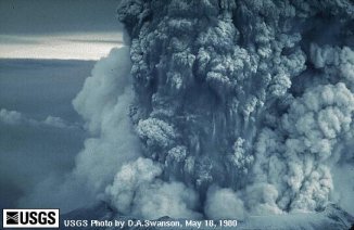
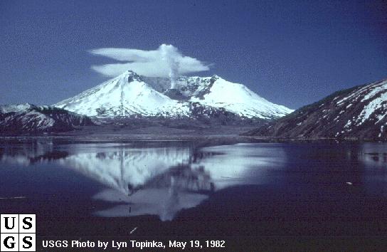
Mount Saint Helens, USA  


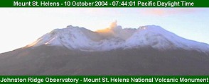
Later events - up to date - click here: St.Helens now.

From October 17th till November 7th no reports as we have been away

Saturday, October 16th, 2004
As we have to go away, next update will be around November 5th.
Till then we recommend you look up the links above.
KIRO TV has an excellent page about the ongoing and past activity
with several slide-shows and images like these:
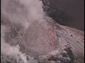
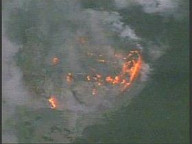
 
© KIRO TV


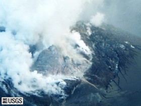
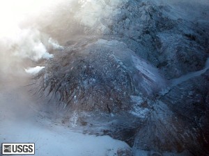
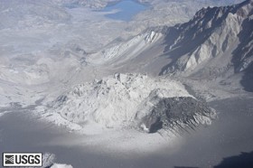
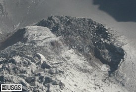
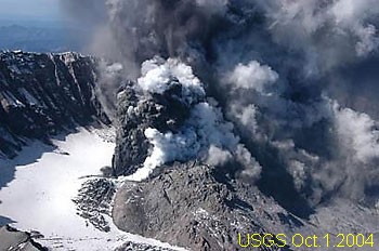
Mount St. Helens uplift with new growth and new avalanche fan, as seen from high angle on the north.
USGS Photograph taken on 14 October 2004, by Jim Vallance.

The stone ‘‘fin'' on the new lava lobe inside the crater at Mount St. Helens seems to be starting
to split, scientists reported Friday.
The fin, which is about 200 feet tall and 300 feet wide, is
building on the new lava dome, which is about 1,600 feet in diameter and 400 feet high,

Friday, October 15th, 2004, 18.15 PDT (Thursday), 01:15 UTC Friday
The area of both the uplift and the new lobe of lava have increased slightly since yesterday.
Yesterday’s gas-sensing flight detected low levels of sulfur dioxide and hydrogen sulfide, but no
carbon dioxide. Abundant steam continues to rise from the area of lava extrusion to the crater rim


USGS image taken on 13 October 2004, by Rick Wessels and Mike Ramsey

Small emissions of steam and ash are possible. Reflection onto steam clouds of incandescence
or glow from the hot rock and gases will be visible at night from some locations.

Lava-dome growth is a dynamic process and, as we observed in the mid-1980s, Mount St.
Helens and similar volcanoes elsewhere typically go through episodic changes in level of activity
over periods of days to weeks, or even months. We expect fluctuations in the level of eruptive
activity to continue. Escalation could occur suddenly.


USGS image taken on 13 October 2004, by Rick Wessels and Mike Ramsey

Under current conditions, small lahars (volcanic debris flows) could be triggered if hot material
from the new lava extrusion swiftly melts glacier ice. Such lahars pose negligible hazard below the
Sediment Retention Structure (SRS), but could pose a hazard to people working or recreating
along the river channel upstream of the SRS. Furthermore, due to weather and stream-flow
conditions at this time of year, it is not unusual for rivers draining the volcano to contain high
concentrations of sediment that turn the water murky.
There will no longer be daily media briefings at the Headquarters of the Gifford Pinchot
National Forest. (From USGS)

More lava emerged Thursday on the crater floor of Mount St. Helens, expanding a rock
formation building on the volcano's old lava dome.
Airborne observers have seen "vigorous jets" of ash and steam near the new growth. Aerial
photographs suggest some uplift on one side of the emerging rock "fin."

Thursday, October 14th, 2004, 18.00 PDT (Wednesday), 01.00 UTC Thursday


Mount St. Helens crater dome and uplift with new growth,
as seen from the west.

USGS Photograph taken on 12 October 2004, by Jeff Wynn

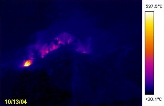
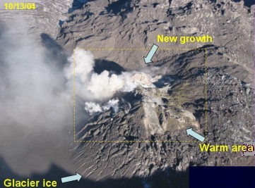
Seismic activity remained at a low level Wednesday, maintaining the slight increase that occurred
last night. This morning’s visual observations and thermal imaging of the crater were focused
on the intensely deforming and uplifting area on the south side of the 1980-86 lava dome
and the new lobe of lava in the western part of that area.
The area of both the uplift and the new lobe of lava have increased slightly since yesterday.
Temperatures of almost 700 degrees C were measured in parts of the new lobe, from which
ash-rich jets rose tens of meters. Abundant steam continued to rise from the area of lava
extrusion to the crater rim, from which it was dispersed southwestward by strong winds.
From USGS
That message verifies what we believed was the glow of lava on the pictures shown below
from yesterday. Newspapers in USA have also reported same, and AP press has made a
picture available, showing the lave-extrusion - you can see the picture here, at least for a while.

Wednesday, October 13th, 2004
noon (norwegian time)
  
something strange going on..... could it be glowing lava?
Compare the two pictures to the right with an old day-time picture(left).
Since midnight St.Helens time, or 09.00 CET (norway) there has been spots like these.


morning (norwegian time)
    
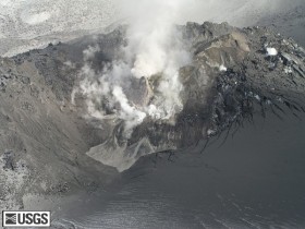
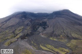
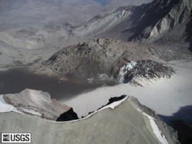
Left: Mount St. Helens dome and uplift from the east. Right: From the west.
USGS Photographs taken on 11 October 2004, by Kirstie Simpson and Jon Major

Seismic activity remained at a low, but gradually increasing level yesterday. Tuesday morning’s
visual observations and thermal imaging of the 1980-86 lava dome, the intensely deforming and
uplifting area on the south side of the dome, and the new lava extrusion first seen yesterday
afternoon were hampered by steam clouds. Conditions appeared similar to those of yesterday
afternoon, with high temperatures (up to 600 degrees C) around the fin-shaped lava extrusion in
the western part of the uplift. The area of high temperature appears to have increased in size.
Abundant steam continued to rise from the fin area to the crater rim, from which it was
dispersed southeastward by strong winds.

As a result of the intense unrest of the past two and one-half weeks and recent observations,
we infer that magma is at a very shallow level and is likely extruding onto the surface.
As last night (Tuesday), incandescence from hot rock or gases could reflect off steam clouds
and be visible from north of the volcano. During times of unrest, Mount St. Helens and similar
volcanoes elsewhere typically go through episodic changes in level of unrest over periods of
days to weeks, or even months. Such changes are in part driven by variations in the rate of
magma movement. (From USGS)
(Looks very much alike what is going on at Etna at present.)

Tuesday, October 12th, 2004
 
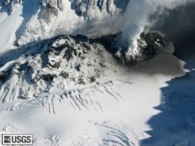
Left: St. Helens dome and uplift as seen from the northwest. Right: Crater and dome from northeast
USGS Photographs taken on 10 October 2004, by Jim Vallance
Tuesday morning: (midnight in Washington): No change in activity. Smoke coming up,
and quakes every 5 to 10 minutes.
According to USGS survey Monday, new thermal images reveal that parts of the lava dome in
Mt. St. Helens' crater are getting hotter and scientists said that an area on the south side of the
dome appeared perforated, as if magma has been hammering at the surface.
"What's happened in the last day is the magma is not just pushing up but pushing out.
We no longer have just isolated vents. Instead, the whole area is pushing up, the gas is
the fuse, just oozing out," a U.S. Geological Survey geologist, said. He said scientists believed the magma, or molten rock, was less than half a mile below the surface.

The glacier, which is a newcomer in USA, began to grow after the 1980-eruption. It is now
3,500 feet wide between the south side of the lava dome and the crater wall. Some parts are
600 feet deep, although the average is 325.
Scientists are calculating now how much water that translates to. Anyway, it would have to
break up an enormous amount of material, if St.Helens wishes to.
Only one other volcano -- in Katmai, Alaska -- has hosted glaciers that have grown as quickly
as this one.
Recent activity at Mount St. Helens is lifting part of the glacier.Some layers are nearly vertical
right now at a site on the southeast side of the dome where underground pressures are lifting ice
and stone almost as high as the 1,000-foot-tall lava mound.
The still-unnamed glacier contains about 120 million cubic meters of snow, ice and rock.

Monday, October 11th, 2004
As the sun started to rise Monday in western Washington, a small cloud could be seen rising
slowly up from the crater.
The volcano vented steam for several hours Sunday.
Scientists believe it happened after part of the south side of the lava dome in the crater broke off,
taking some of a glacier with it.
Seismic activity at the mountain remains relatively low.

USGS 07:45 PDT 14:45 UTC

Seismicity overnight remained at a low level similar to October 10. Small earthquakes
(about magnitude 1) have continued at a rate of about 1 per 5 to 10 minutes.

Viewing conditions were very clear most of October 10, and fresh snow had fallen to the level
of the crater floor north of the dome. A USGS field crew noticed a thin ash deposit on the
snow in the crater and just beyond the crater rim, trending southeast from the active area.

A steam plume rose to crater rim level or slightly above all day on October 10, heading to the
southeast. USGS field workers described the plume as “lazy”—no gas thrust or notably
vigorous convection was observed. The plume was clean, with no noticeable ash or blue/orange
haze. The odor of H2S was noted at the crater breach, but not elsewhere.

Maximum measured surface temperatures were 200-300 C. (More than sufficient to fry eggs)

Sunday, October 10th, 2004
LATEST 13.00 PDT - 18.00 UTC

 
At 07:44 PDC and 11:24 PDT today Sunday
The dark steam rose at dawn (07.00 PDT) from an area of the crater where rock has been
growing rapidly upward. The plume rose several hundred feet above the volcano, and light wind
slowly blew it toward the south and southeast.
Scientists didn't immediately determine whether the steam cloud contained any volcanic ash.
Quakes are down below M1, and not so frequent any longer.

- 05:30 p.m, PDT (Saturday) - 00.30 UTC (Sunday)

A snow-covered Mt. St. Helens Saturday

Seismic activity has remained at a moderate, but variable rate. Currently earthquakes up to
magnitude 2 are occurring at a rate of about 1 every two to three minutes minutes.
No visual observations of the crater, the 1980-86 lava dome, or the intensely deforming and
uplifting area on the south side of the dome were possible today due to low clouds.
No scientists worked in the field today.
At 01.00 PDT - 08.00 UTC quakes have declined considerabale compared to those of yesterday.

Additional analysis of lidar and photographs of the intensely uplifting area on the south side
of the lava dome suggests that the total volume change represented by the deformation between
late September and October 6 is about 16 million cubic meters (21 million cubic yards).
The average rate of change is about 2 million cubic meters per day (2.6 million cubic yards per
day). If this figure represents the rate of intrusion of magma into shallow levels of the dome
and(or) underlying crater floor, it is an intrusion rate about twice that measured during dome-
building eruptions at Mount St. Helens in the 1980s.

Saturday, October 9th, 2004

Seismic recordings nearSt.Helens.
Upper: 5 hours from 17.oo PDT Oct.7
Middle: 5 hours from 05.00 PDT Oct 8.
Bottom: 6 hours from 17.00 PDT Oct 9
or from 00.00 to 06.00 today saturday UTC.

Seismic activity has been rising gradually today to a moderate rate of energy release, with
earthquakes up to magnitude 2.4 occurring at a rate of about 1 every two minutes.
No visual observations of the crater and dome were possible today due to low clouds and rain.
AFM data suggest a small lahar flowed out of the crater about midday.


View from the south-southeast side of Mount St. Helens lava dome looking at the lava dome
(behind) and the uplift of the glacier and south flank of the lava dome (in front).
USGS Photograph taken on 7 October 2004 at 09:05:43 PDT, by Steve Schilling.

Measurements from recent photographs and LIDAR (an acronym for LIght Detection And Ranging) show that the intensely deformed and uplifted area on the south side of the
1980-86 lava dome is about 1300 feet (N-S) by 1600 feet (E-W) with a maximum uplift
of about 300-400 feet. (From USGS)

Friday, October 8th, 2004
17.00 PDT 24.00 UTC still rising
13.00 PDT 20.00 UTC quakes still increasing in strength
08.00 PDT 15.00 UTC
Looks like seismic activity are slowly increasing, although not so frequent, but more intense.
Weather is poor, raindrops fall on the web-camera. The uplift of the area is from 30 to 200 m
during the last week, according to different news media all over the world. USGS, which we
recognize as the most reliable, says about 80 m since the beginning of the eruption-periode.

7:00 a.m., PDT 14.00 UTC
Seismic activity continues to be at a low to moderate rate with an overall trend of slightly
decreasing energy release over the past 24 hours. Earthquakes are occurring at a rate of
1 to 2 per minute with the largest magnitudes about M1.5.

( 6:15 p.m., PDT yesterday - 01.00 UTC today)

    
Left: View of Mount St. Helens crater and the Sasquach Steps as seen from the north.
The dark "muddy" looking area in the right foreground is old erosional debris flows from Step
Channel (on right) over the years. The lighter ribbon of grey to the left of the darker area is a
flow from Loowit Channel from early morning of October 6, 2004. Right: Close up of Loowit Channel.

USGS Photographs taken on 6 October 2004 by John Pallister.

Seismic activity has been at a low to moderate rate today, with earthquakes of magnitude
1 to 2 occurring at a rate of about 1 per minute. Visual observations of the vents and the area
of intense uplift on the south side of the 1980-86 lava dome suggest that there has not been
noticeable additional uplift in the past 24 hours. However, a new steam vent opened overnight
to join the two that have been present for several days. Steaming from the vents generates a
cloud that rises above the south side of the lava dome and extends a variable distance toward
the crater rim.

Thursday, October 7th, 2004 (6:00 p.m, PDT
yesterday) 03.00 norw.time.
    
Pictures from the eruption on October 5th, resp. at 09.29, 98.50 and 09.56 PDT
See satellite photo below the diagram on Oct.6th further down this page.
USGS Photographs, by Steve Schilling

The low rate of seismic activity that followed yesterday’s steam and ash emission continued
through last night, but rose slowly between about 9 a.m. and 1 p.m. (see diagram below), before
leveling off at a slightly higher level. Earthquakes are presently occurring at a rate of about one
per minute with a maximum magnitude of about 1.0.
No thermal observations were possible today owing to low clouds and rain, but late this
afternoon scientists were able to get brief views of the vents and the area of intense uplift on the
south side of the 1980-86 lava dome. They saw only weak puffs of steam coming from vents.
They were able to confirm that the top of the area of intense uplift is at or slightly above the
highest point on the lava dome, which suggests that some uplift has occurred during this period
of low seismicity. They were also able to observe areas affected by the small lahars that spilled
out of the crater and onto the Pumice Plain during last night’s rain storm.
Information received today indicates that a light dusting of ash from yesterday’s event affected
the eastern part of Mount Rainier National Park, about 70 miles north-northeast of St. Helens.

Wednesday, October 6th, 2004
LATEST 9:15 A.M., PDT  16:15 utc
usgs MESSAGE: We infer that the vigorous unrest of the past few days has lessened
and that the probability of an imminent eruption that would endanger life and property
is significantly less than at any time since Saturday, October 2, when the alert level
was raised to Volcano Alert (Level 3). Therefore, we are lowering the alert level to
Volcano Advisory (Alert Level 2).


FOLLOWING QUAKES ARE REGISTERED AT ONE OF THE STATIONS NEAR
THE SUMMIT AND SHOWS AN INCREASING ACTIVITY. SO NOW WHAT?


Oct. 5, 2004 10.00 PDT 17.00 UTC Cloud drifting northeast about an hour after the eruption

 
Left: Aerial view of Mount St. Helens crater and dome, showing ash covered areas,
and new vent. Spirit Lake is in the background.
Right: Mount St. Helens dome and jumbled glacier, from the west.
USGS photograph taken 4 October, 2004, by Gene Iwatsubo.
Yesterday morning, local time, the rate of seismicity was at a high, sustained level when,
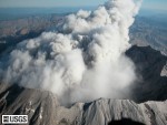
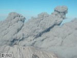
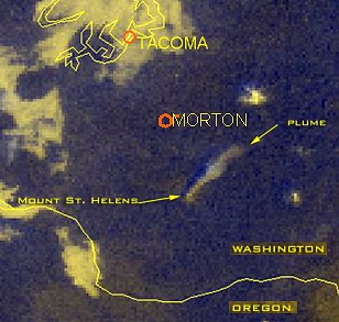
shortly after 9:00 a.m. PDT, (16:00 UTC) the most vigorous steam and ash emission of the
current period of unrest began. See picture below "another one?".
The emission originated from the same vent as have others this past week, as well as from
another nearby new vent in the intensely deforming area on the south side of the 1980-86
lava dome. For more than one hour, steam clouds billowed from the crater. The ash content
varied with intensity of steam jetting from the vent. For the first time, ash content was sufficient
that it was detected by National Weather Service Doppler Radar.
Steam and ash clouds reached about 12,000 feet and drifted north-northeastward.
Ash forecasts warned downwind residents. Media reports indicate that a light dusting of ash
fell in Morton, (see sattelite picture above) Randle, and Packwood, Washington, towns
about 30 miles from the volcano. Nearby traffic on U.S. 12 stirred up the ash, slightly reducing visibility. We have no reports of ash falling at greater distances.
The rate of seismicity dropped during and the emission and has stayed at relatively low rates.
We infer that magma is at a very shallow level and could soon be extruded from a vent in the
deforming area. Additional steam and ash emissions are likely and could occur at any time
without warning. Conditions suggest that there is also an increased probability of larger-
magnitude and more ash-rich eruptions in coming days.
From USGS

Tuesday, October 5th, 2004

09:09 PDT 16.00 UTC - another one?!

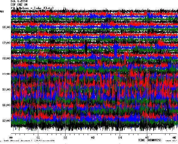
16.00 local time in Norway (07.00 AM PDT)

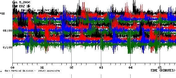
Real time seismic data, from 05:00 to 07:00 PDT, or 12:00 to 14:00 UTC this morning at
a seismic station located near the summit. Look like it works......

Visual observations show that the area of uplift, which includes part of the glacier and a
nearby segment of the south flank of the lava dome, continues to rise. So far it is reported to
have increased by more than 30 meters. Thermal surveys of the dome confirms the
deformation. Hot cracks (40-50° C; well below magmatic temperatures) in the dome are
opening, and dome rocks are avalanching off the dome into the lake and onto the south
crater floor. The north flank of the dome appears thermally stable.

Yesterday’s gas-sensing flight detected carbon dioxide, often in association with hydrogen
sulfide peaks and occasional sulphur dioxide peaks, at numerous sites around the dome
and crater floor.

08.00 local time in Norway.(7:00 P.M.PDT Monday)
Yesterday visitors to Mount St. Helens witnessed a 40-minute-long steam-and-ash emission
starting at 9:43 PDT. Steam clouds carrying minor ash billowed out of the crater to an altitude
of 10,000 to perhaps 12,000 feet. The event did not generate earthquakes or an explosion
signal. We infer that hot rock was pushed up into the glacier, melted ice, and generated the
steam. Part of the vent for today’s and other steam and ash emissions of the past few days is
now covered by a boiling lake. The emission occurred during a time of gradually increasing
seismicity, which dropped slightly after the emission, but continued to increase gradually through
the afternoon.


Mount St. Helens dome as seen from above the southwestern crater
rim. Ash from the plume of 10-01-04 is visible on the glacier at the
base of the dome. The vent from that event is visible at the base of
the dome on the right.
USGS photograph taken on October 3, 2004, by Stephanie Konfal and Dan Dzurisin

Another period of smaller steam and ash bursts occurred between 2:10 and 2:40 P.M.
Visual observations show that the area of uplift, which includes part of the glacier and a
nearby segment of the south flank of the lava dome, continues to rise. We infer that magma
is at a very shallow level and could soon be extruded into the vent or elsewhere in the
deforming area. Additional steam and ash emissions are likely and could occur at any time
without warning. Conditions suggest that there is also an increased probability of larger-
magnitude and more ash-rich eruptions in coming days.

Monday, October 4th, 2004
10:00 PDT - 19.00 norsk tid


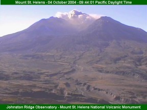
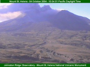
A steam explosion blanketed the top of Mount St. Helens on Monday.
The eruption occurred from the south end of the volcano's crater. U.S. Geological Survey
said they did not immediately know the ash content of the plume.

"Hopefully after this clears away our crews will get a view of the crater, and the crater will
probably be enlarged a bit," The steam burst occurred as small earthquakes were recorded
at the southwest Washington mountain.

The cloud appeared to be mostly white, and USGS said whatever ash was in the plume would
fall mostly in the crater. The steam burst, at about 9:35 a.m. (PDT), slowly rose above the
remote peak, but did not immediately threaten any structures within the national monument.

At 07:40 PM PDT yesterday - at 02:40 UTC today the following message was issued:
At 2 pm Saturday, we increased the alert level to Volcano Alert due to a change in the
character of seismic signals (50 minute long tremor) that occurred immediately after a steam
emission at 12:16 P.M., recognition of ongoing uplift of the crater floor, and reports of sulfur
gas odor. In addition, we believe that there is a significantly increased probability that gas-rich
magma is moving toward the surface. After another period of tremor starting at 2:57 A.M.
Sunday, seismicity returned to discrete earthquakes. Seismic activity decreased gradually until
about 2:00 P.M. then increased again, reaching levels comparable to those prior to steam and
ash eruptions. M3 earthquakes (Richters scale) are occurring at a rate of about one every 5
minutes. All earthquake locations remain shallow.


Large cracks appear in the glacier around the lava dome in Mount St. Helens, Sunday, Oct. 3.
© AP Photo/Don Ryan

Yesterday’s gas sensing flights detected significant concentrations of carbon dioxide north and
west of the dome. No significant levels of sulfur gasses were detected. Hydrogen sulfide
odors detected by helicopter crews are attributed to steam emissions. These low levels of
hydrogen sulfide are likely the result of boiling of the hydrothermal system.

Results from GPS measurements indicate no significant deformation of the outer flanks
of the volcano. However, visual observations and photographic analysis show large-scale
uplift (10’s of meters) of part of the glacier and a nearby segment of the south flank of the
lava dome. This suggests rise of magma to shallow levels. Additional steam and ash eruptions
could occur at any time. There is also an increased probability of larger magnitude and more
ash-rich eruptions.


A beautiful day, Sunday Oct. 3rd - while waiting for St. Helens next move.

Sunday, October 3rd, 2004
LATEST: 12 NOON PDT, 21:00 in Norway
Scientists detected a volcanic tremor at Mount St. Helens early Sunday, just hours
after officials raised the volcano's alert level, cleared hundreds of visitors from the
area and warned a major eruption was imminent.

Sunday's tremor lasted about 25 minutes and was milder than the 50-minute tremor that
followed a steam release Saturday, according to the the U.S. Geological Survey's Cascade
Volcano Observatory.

"It just means that what's been happening is still happening" and the volcano is moving
toward an additional eruption, Wynn said.

People pitched tents alongside park roads and spent the night waiting to see what the
rumbling volcano would do. Saturday was the busiest day ever at visitors' centers on
the mountain, with thousands of people packing buildings, crowding parking lots and
sitting alongside roads in lawn chairs.

One woman said she saw the plume at midday and was afraid she'd miss something if she left the area. "I just stare at it and stare at it. It's too awesome to leave," she said.

8:00 A.M. PDT - 15.00 UTC - 17.00 local time in Norway

Current status is Volcano Alert (Alert Level 3); aviation color code RED

Overnight (about 3 am) there was a tremor burst that lasted about 25 minutes. No eruptive plume was detected as a result of this tremor. Following the tremor, seismic activity dropped, but now is at a level similar to that before the tremor burst. Earthquakes are occurring at a rate of 1-2 per minute with maximum earthquake magnitudes of about M3. All earthquake locations remain shallow. During yesterday’s gas flight, scientists saw an increase in the number of fumaroles on the lava dome and detected some carbon dioxide. The total amount awaits further data reduction. Scientists also reported intermittently the smell of hydrogen sulfide (rotten-egg smell) over the crater. Data from the GPS instruments on the flanks of the volcano show no significant changes. Results from the FLIR (thermal imagery) data to date show no significant thermal anomalies in the crater or on the dome. Scientists will be in the field today to harden GPS sites, do another FLIR flight, and conduct another gas flight.

Sunday morning (in Europe)
Hundreds of visitors at an observatory eight kilometers from the volcano were
asked to leave the area.

The mountain quieted after spewing huge clouds of steam Friday. But by Saturday morning,
scientists say energy releases were higher than they were before Friday's blast.

Current status is Volcano Alert (Alert Level 3); aviation color code RED

At 2 pm Saturday, we increased the alert level to Volcano Alert due to a change in the
character of seismic signals (50-minute-long tremor) that occurred immediately after the
small steam emission at 12:15. Seismic activity changed from principally rock breakage events to continuous low-frequency tremor, which is indicative of magma movement.

Since the tremor stopped, seismic character has changed back to the type of earthquakes
we have detected since the beginning of the volcanic unrest. Earthquakes are occurring at
a rate of 1-2 per minute with maximum earthquake magnituesof about M3. All earthquake
locations remain shallow.

Saturday field crews took additional thermal images of the dome and crater. Deformation
crews were in the field retrieving data from GPS instruments. Results are not yet available
from today's late gas flight.

Saturday, October 2nd, 2004


From USGS 7 PM PDT, around midnight in Europe.
The increasingly energetic seismic swarm of the past week culminated in a small 25-
miunute-long eruption around noon today from a vent just south of the lava dome.
The vent opened in a portion of the glacier that had become increasingly crevassed
and uplifted over the past few days. This deformation was probably driven by piston-
like uplift of a portion of the lava dome and crater floor.

The eruption sent a steam and minor ash plume to an altitude of about 10,000 ft.
It drifted southwestward accompanied by minor ashfall in areas close to the volcano.
Seismicity dropped to a low level for several hours after the eruption, but is gradually
increasing with earthquakes (maximum Magnitude about 3) occurring a rate of 1-2
per minute. We infer that the system is repressurizing. As a result, additional steam-
and-ash eruptions similar to today’s could occur at any time.
erupted for the first time in 18 years today, belching a huge column of white steam
and ash after days of rumblings under the mountain.

The noontime eruption cast a haze across the horizon as the roiling plume rose from the nearly
1,000-foot-tall lava dome, forcing Alaska Airlines to cancel flights and divert others around the
ash. No evacuations were ordered, and there was no sign of any lava oozing from the volcano.

Thursday, September 30th, 2004
Increased seismicity overnight prompted raising the alert level to Volcano Advisory (Alert
Level 2) at 10:40 A.M., PDT, this morning (Sept.29th). Throughout the day the seismic
energy level has remained at an elevated with a rate of 3-4 events per minute including an
increase in the number of events between Magnitude 2 and 3. All earthquake locations are
still shallow and in or below the lava dome. In addition, initial data from the GPS instrument
on the lava dome that was repaired Monday morning suggest that the site moved a few inches
northward Monday and Tuesday, but has since been stable. Such movement is not surprising
in light of the high seismicity levels

Confusion at this morning’s press briefing at CVO regarding Alert Levels resulted in numerous
calls to emergency management agencies from the public about which is the correct level.
We are at Alert Level Two

Wednesday, September 29th, 2004
Late evening (Central European Time)
Mount St. Helens began rumbling more intensely today, prompting scientists to raise the
eruption warning level to 3 (wrong - see Sept. 30th above) on a scale from 1 to 4, and
suggest a blast could cover an area 3 miles around the volcano's crater.
Earthquakes ranging from magnitude 2 to 2.5 were coming about four times a minute,
possibly weakening the lava dome in the crater of the 8,364-foot mountain, the U.S.GS said.

Midday:
As of the 29th of September, the United States Geologic Survey (USGS), has reported that
seismic activity has remained high at Mt. St. Helens volcano, with about two small earthquakes
occurring every minute. The earthquakes are shallow and located under the lava dome.
US Geological Survey personnel have talked with Washington State and County emergency-
management officials to discuss hazard and response issues. The current state of unrest at
Mt. St. Helens volcano indicates an explosion is possible at the volcano at any time, which
could eject large rocks as far as the crater's edge.

Monday, September 27th, 2004
Hundreds of small earthquakes continue at Mt St Helens volcano. The earthquakes have been
recorded since about 2 a.m. Thursday (Sept 23rd), and were still continuing 36 hours later.
The earthquakes are within a half mile of the surface and too small to feel. They are under the
lava dome. The current earthquake swarm could increase the chances of small landslides and
debris flows in the crater itself and up to several miles north of the crater, in an area known as
the Pumice Plain. The shallow earthquakes likely are the result of cool rains seeping beneath
the crater and reaching hot rocks, which creates steam and pressure. They could also be
caused by magma rising towards the surface, cracking the dome on ascent. We volcanologists describe such episodes as "refuelings" of the volcano, but we don't know how much fresh
molten rock is needed to trigger a new series of eruptions.
From SWVRC


Before - and after the explosion

 
Not many trees standing up any longer....


http://www.usgeology.com/eruptiontypes.html


Ash-deposits from St. Helens May 18th, 1980, measured in millimeters.


BEFORE/AFTER #2: Mount St. Helens and the devastated area is now within the 110,000-acre Mount St. Helens National Volcanic Monument, under jurisdiction of the United States Forest Service. Visitor centers, interpretive areas, and trails are being established as thousands of tourists, students, and scientists visit the monument daily. Mount St. Helens is once again considered to be one of the most beautiful and interesting of the Cascade volcanic peaks. (May 19, 1982, by Lyn Topinka, USGS/CVO)


Linker:
 Mount St.Helens A General Slide Set by Lyn Topinka, USGS/CVO/WRD

 Mount St. Helens Photo Page , Stromboli on-line italiano-deutsch-english
Google
 
Web www.vulkaner.no


bukkm.gif
ANIMALS

over 250

birdm.jpg
BIRDS

over 500

flower.jpg
FLOWERS

over 300
dolphin.gif
SEALIFE
globe.gif
TRAVEL
globe.gif
VOLCANO


    alfabetisk liste
    alphabetic list


Denne siden er laget ved hjelp av Macromedia Dreamweaver