This map shows the situation as it currently stands. Mount Nyiragongo
stands in an area of incredible unrest. Rwanda - site of many a civil
war. Even in the Democratic Republic of the Congo (DRC), Politically,
the situation is and has been, highly explosive.
The town of Goma is situated less than 10km from Nyiragongo, and is
in the path of the volcano. Lake Kivu is part of the East African
rift network. Goma is surrounded by danger,
and Nyiragongo is possibly the greatest.

A
vast number of people live in an area of incredible danger. The following
map is an
excerpt from the United States Geological Survey, and shows the area.
Nyiragongo is clearly marked, as is her sister, Nyamuragira.
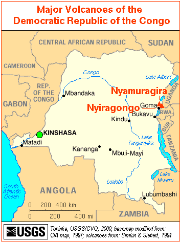
Nyamuragira is a shield volcano whose eruptions, such as the one
at the end of 2001,
rarely cause loss of life. In contrast, Nyiragongo is a stratovolcano,
spattered with almost a hundred parasitic cones. And its greatest
hazard is its lava.
Under normal circumstances, lava is not particularly a major hazard.
However, Nyiragongo's
has an extremely unusual chemical composition, and thus it flows rather
like water. Some instruments have indicated speed of flow exceeding,
on occasion, 100 miles per hour.
Naturally, this varies depending on how hot the lava is, and also
according to the local
topography; but this lava makes Nyiragongo one of the most hazardous
volcanoes on the
planet, and it is definitely in the top fifteen potentially most dangerous.
Disasters have been seen before, and will be seen again.

The summit of Nyiragongo contained an active lava lake from 1874
to 1977. This lava lake
was another unusual feature of the volcano. In 1977, however, disaster
struck.
To say the volcano 'exploded' would be incorrect. A more appropriate
term would be that it 'cracked'. In his book 'The Fires Within', David
A. Hardy gives the following brief
description of the event, which occurred on the 10th January;

The account is not entirely accurate; in fact the lava flow clipped
the side of Goma, reaching to within 600m of Goma airport. This river
of lava was almost 1,000m wide, and this catastrophe caught the globe's
attention. It immediately became obvious that Nyiragongo was, as a
volcano, hazardous in the extreme. Due to poor records, the real death
toll of this event is uncertain. Estimates vary from none, to 2,000.
The Smithsonian Institution favours a figure
between 50 and 100.


In 1994, the sight of a returning lava lake (shown above) in Nyiragongo
enraptured the volcanological community. Experts from all over the
world flocked there, even experts from the Hawai'i Volcano Observatory
(a check of the weekly 'Volcano
Watch' archives will find two articles concerning 'Eruptions in
Zaire' - as it then was).
The crater lake was approximately 400m in diameter, and sent small
flows out onto
the floor of the 800m-crater. It did not, however, cause a catastrophe
as in 1977;
the level of the lava lake would never equal that of 1977.

In 1977 Nyiragongo scratched; in 1994 it flexed its claws; in 2002
it has struck.
The eruption began on 17th January. By the 18th January, some 45 villages
had been
decimated by the surface lava flow. An immediate estimate was of a
death toll of only 45, surprisingly specific; it is unlikely this
estimate will remain so low. The exact details of the
eruption are as yet uncertain. Some reports claim it began at 0500
local time.
Other reports state that, probably around mid-day, fissures opened
north of the Goma Airport, and lava flowed out at 2 - 3 miles a minute.
The lava flowed straight towards Goma.
By the afternoon of the 17th January, the debate on when the eruption
started was irrelevant.
The lava flows entered Goma.

Through the night, all that could be seen was a dark cloudy sky,
illuminated by the advancing
lava front; shown above. The stillness was only disturbed by occasional
explosions, as gas
depots were detonated. Seismic activity remained intense - indicating
the threat of further activity. It is estimated that, in places, the
lava flows were over two metres high and thirty wide.
At least two eruptions were seen. One eruption occurred about a kilometre
from the airport, creating a huge fissure 1km long. The other occurred
north-west of Goma.


This
is an image of the advancing lava flows.
By the morning of the 18th, nearly a third of Goma was ablaze. By
this time, some of the lava
flows had stopped; in other areas, residents could only stand watch
in awe and horror as the lava continued in its relentless advance.
The lava flow in the picture below is still active, still advancing.

Agence France-Press reported "The town is completely destroyed,
everything must be started up from scratch." Parts of the runway
at Goma airport had disappeared under lava flows; a major part of
the airport was damaged when kerosene storage facilities detonated,
burning for a long time. Florian Westphal, a spokesperson for the
International Committee of the Red Cross, said: "Our warehouse
and workshop garages with seven trucks have been destroyed. The airport
is unusable, and the port has been destroyed by a fuel explosion."
These problems are sure to hamper relief efforts. The first photograph
shows the airport itself; the second is of sheds nearby to the airport.


The city had become a ghost-town.
The wealthy area of Himbi appears to have been spared. More hilly
than the rest of Goma,
its slopes served as a barrier to a lava flow at least 2km wide.
The lava flow terminated at Lake Kivu. While there are fears of contamination
of the lake water,
the immediate fears - of explosions as the lava met with the water,
similar to those sometimes
seen on lava benches on Hawai'i - seems to have been proved unjustified.
Most of Goma's residents have fled to the town of Gisenyi, in Rwanda.
However, at one point
this haven seemed itself endangered from a lava flow - which thankfully
has stopped advancing.
The interior minister of Rwanda stated, "The town's population
should stay on alert, and be
prepared to evacuate the town at a moment's notice."

