|
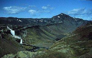
Katla, a 4.961m tall volcano
in Iceland. As many other volcanoes, this one is also below a glacier,
Mýrdalsjökull.
Beside Hekla then Katla is the most
known volcano in Iceland. Its position is at 63.63N 19.05 W
Myrdalsjökull cover 580 km² and the thickness of the icecap is between
300 - 600 mt.
In historic time Katla had about 20 eruptions haven taken place in 1580,
1612, 1625, 1660, 1721, 1755, 1823, 1860
and 1918.The last eruption was in 1918, and began October 12th to November
4-5th.
In the beginning of July 2002 a certain activity was registered, but
no eruption developed.

(nodak)
February
- March and April 2012
There have been a lot of rumors about Katla preparing
for a large, much large, eruption in the near future.
We normally do not write about such rumors, even if there is some truth
therein, as a lot of volcanic
activity occurs daily around the globe. But we are aware, and if the
situation changes, we will be ready
to give you reports.
Friday,
October 14th, 2011
Scientists warn that a new eruption may occur within shourt, as the
seismic activity in the area has developed.
The news agencies report that small earthquakes around the volcano have
not only been increasing in frequency;
they've been increasing in magnitude, going from about 3 on the Richter
scale to 4 last week.
For the moment, Icelandic scientists are keeping a close eye on the
volcano, and keeping civil authorities informed.
Evacuation procedures are already firmly established in the event of
an eruption.
For now, though, the volcano remains quiet.
More about Katla:
An eruption
from Katla is serious as populations are not far away. Closest to the
volcano is the small community Vik,
on the coast just south of the glacier. Vik is connected to the rest
of Iceland through the mainroad, No 1,
which encircles all around Iceland. This road passes through Myrdalssandur,
which is a sandy delta area
which have come after eruptions from Katla. The sandy area is about
20 kiilometers wide, and are fully
overrun by water when there is a 'hlaup', that is a flood of melting
water from under the glacier.
Read more about this here: Vatnajökul.
 Deepening
in the glacier Myrdalsjökull on top of the volcano Katla
Deepening
in the glacier Myrdalsjökull on top of the volcano Katla
The eruptions
from Katla often follows
immideately after a quake the same day, or the day before.
Probably it will take from twelve to twentyfour hours till the eruption
breaks the glacier.
When it comes up in daylight, vapour together with gasses and ash are
sent way up into the atmosphere,
forming a cloud that reaches 10-15.000 m above sealevel (asl)In this
cloud you will see much lightening.
See more here: Vatnajökul.).
An estimate of the melting water during such an eruption is about 1
billion cubicmeter, and because of the
difference in alterations between Katla and the sandy
coastline about 600 to 800m lower,
the water is coming down with an enormous force.
The speed of the water will be 20 - 30 km an hour, and will consists
of 100-200 000 cubicmeters per second.
A flood like this could last from 10 to 20 hours and lead to serious
damage.
Previous history
Katla has usually erupted
at intervals of 40 to 80 years and melted such volume of ice, that the
flood waves have
covered most of the Myrdalssandur outwash plain, the Solheimasandur
plains, and even the Markarfljot plains.
The peak volume can be compared with River Amazon.

©
www.vulkaner.no
Documented sources about earlier eruptions and floods seem to be relatively
reliable from around 1179.
The Katla caldera is the southernmost part of a 75 km long fissure system,
which extends almost all the way to
the western edge of the Vatnajokull
ice cap. According to the latest results of scientific research in that
area, the total
length of this system erupted during the period 930-940, emitted about
19 km³ of tephra and created a lava field
of about 800 km². This eruption is considered the largest historical
eruption of the country, and for that matter
of the whole world.

©
www.vulkaner.no
The eruptions in 1245 and 1262 are said to have created
most of the outwash plain Solheimasandur and the
1311 eruption caused the so-called Sturla Flood, which devastated the
farming area called Lageyjarhverfi on the
outwash plain Myrdalssandur. The 1416 and 1490 eruptions caused the
thickest ash layers in the Southwest,
now the capital area. In 1755 (Oct. 17th), the eastern part of the Myrdalssandur
was once more flooded,
when quite a few people were travelling across. All escaped, some narrowly
though, but some sheep were lost.
The ash layers were very thick and poisonous. This caused great losses
of livestock and consequently human lives.
The 1860 eruption caused floods to the west of the freestanding mountain
Hjorleifshofdi. The 1918 eruption lasted
from October 12th to November 4th. The flood created a spit of land
east of Hjorleifshofdi, which became the
southernmost point of the country until it was gradually transported
away by the ocean currents.
Before the eruption, the depth of the sea, where it was created, was
measured between 2000 and 3000 fathoms.
From © http://www.nat.is/travelguideeng/volc_katla.htm
|